Categories
Construction General Live-work-play Rapidways Urban Planning

Getting the GTHA Moving

Everyone is hearing a lot these days about the need for more transit in the GTHA, and how increasing traffic congestion is hurting our economy.  The Toronto Board of Trade puts a $6 billion a year price tag on the cost of congestion. But beyond the headlines, many people don’t really understand exactly how traffic congestion and the lack of transit hurts the economy, and why this issue matters to every one of us in this region – and even to the rest of the province and country.

To help connect the dots, I recommend a recent panel discussion held on TVO’s The Agenda, which covered the issue clearly and logically.  This discussion provides an excellent overview of the issue, in a non-partisan, objective way.  Click here to view the episode.

What I found most interesting about this discussion was how it was explained that the lack of transit hurts everyone, whether or not they’re transit users now, or even want to be transit users.  Even people living in small communities that aren’t experiencing traffic congestion  in fact are economically affected by it. The negative impacts of congestion  in the GTHA, given how important this region is to the economy of the entire country, truly do affect the entire country.  One large business that chooses to open up in the USA rather than in the GTHA due to concerns about congestion hurts all taxpayers in the pocketbook eventually.

Enjoy watching the show and let me know what you think.

Categories
Urban Planning

Designing a complete street for everyone

the Complete Street

VivaNext is of course a project to bring rapid transit to York Region. But our goals are much broader than simply expanding transit (as important as that is for us): our long-term vision is to help York Region, as it grows, to transform beautifully from its suburban past, into its urbanized future.

When I think about the most livable cities of the world, including here in North America as well as in Europe, one feature that makes them distinctive is the way major streets are designed for everyone, and not just for cars.

This approach is captured by the urban design concept known as “the complete street.” That’s the long-standing philosophy behind European urban design, but it is also becoming very influential in North American urban design. The complete street reflects a belief that streets should anticipate and accommodate the needs of all users – pedestrians, transportation users, cyclists and drivers. It means that streetscapes should be designed to provide a welcoming, functional and safe environment for everyone, no matter how they want to get from A to B.

The complete street concept is consistent with York Region’s vision for its urbanized future, especially along its major corridors and emerging urban centres. So the vivaNext streetscape design principles reflect similar values and priorities.

As our work progresses along the Highway 7 rapidway, it’s becoming easier to see how these design principles are going to transform the look and function of the street and its boulevards, for all users.

To begin with, our streetscape design emphasizes the importance of having an attractive public realm, to encourage people to want to spend time in these newly developed public spaces. By offering wide boulevards, with their attractive paving, good lighting, shade trees, amenities such as comfortable benches and generously planted landscaped areas, pedestrians will know that they are truly welcome.

With York Region’s predicted growth, there will be many more people living, working and commuting all along our major corridors, meaning many more pedestrians will be using the sidewalks and intersections. So our streetscape is designed to make everyone truly feel safe and comfortable – after all, Highway 7 and York Region’s other major corridors will continue to be very busy thoroughfares for other vehicles, even once our rapid transit system is up and running. Pedestrians will feel buffered from adjacent traffic by the wide planters placed between the sidewalk and curb. They will have protected places to wait at intersections, and in the median where there are two-stage crossings. All sidewalks and vivastations will be completely accessible. And cyclists will have safe places to ride, and convenient racks to lock up their bikes.

By creating a complete street, our new streetscapes will be walkable, accessible and welcoming for all, no matter how you prefer to get around York Region.

Categories
Live-work-play Rapidways Urban Planning

Why “TOD” is great news for all of us

A rendering of transit-oriented development in Markham
A rendering of transit-oriented development at the future Markham Centre

Recently, I wrote about transit and the role it has in shaping communities, in particular, the development that tends to spring up along transit routes and around stations. This time, I want to talk more about what we mean by “transit-oriented-development” ( TOD for short), and why this kind of development will be good news for people in York Region—whether or not they are transit users themselves.

Most people get around York Region by car – possibly because they want to – but also because some people find it challenging to do all the things they need to do in a day by transit. That’s not surprising in a region like this one; in communities where development has been shaped by a long-standing car culture, destinations are more likely to be spread out, with greater distances between live-work-play destinations. Even the design of buildings may be shaped by car usage, with large parking lots separating buildings from roads.

The idea behind TOD is that people using transit are also likely to be pedestrians at some point during their journey – either at the beginning, or the end (or both). Studies have shown that people are willing to walk about 5 minutes to or from transit, which is somewhere between 400 and 600 metres. So TOD uses the approach of creating a complete community within walking distance of transit – including workplaces, homes, shopping, recreation and services. The thinking is that if new developments are designed to be conveniently compact and appealing to pedestrians, people are more likely to leave their car at home for at least one of their trips. Obviously, the good news is that more people taking transit means fewer cars on the road, less pollution, and less gridlock.

So York Region planners have linked the plans for the vivaNext rapidways to land use policies that will result in more TOD along Viva routes and near vivastations. These policies will likely mean that much of the new development built around vivastations will be compact and mixed-use, providing housing, employment, retail, dining, services and recreation, all within a walkable distance of transit. Developments will also include more welcoming public spaces, attractive landscaping, and other amenities so that people enjoy being out and about.

How will this affect you? In a pre-TOD scenario, a typical day could start with a drive to work, then a drive to a restaurant for dinner, ending with a drive to a movie or concert before driving back home. With more TOD, you would have the choice of taking transit to work, then walking around the corner from the office to dinner, then strolling across the street for a show before grabbing a coffee and getting home again by transit. Same day, two different ways of getting around.

The point is that transit and TOD don’t have to change the way people live in York Region, but it will give us all more choices – in what we do, where we do it, and how we get there. We think that’s good news for everyone.

Categories
Live-work-play Rapidways Urban Planning

Public transit = more housing choices

housingcollage_10_07_12-copy

Here’s some new math you may not have seen before: vivaNext = more housing choices. How can that be? Let’s start by talking about housing options, and why they matter.

The expression, “one-size-fits-all,” applies to many things, but when it comes to housing preferences, we all have our own ideas about how we want to live. A traditional suburban house might be the perfect dream home for one person, but might be too big or too – well, suburban – for another. A stylish condo with a sleek balcony within walking-distance of entertainment and shopping is just what some people are looking for, but wouldn’t suit everyone.

No matter what our personal preferences might be, one of the values that most of us share is that we’d like to be able to choose where we live. Unfortunately, if a range of housing options is not available, it can be difficult for people to find suitable homes in a particular neighbourhood or community. And that’s a shame, because being able to stay in a neighbourhood you like, near friends and family, close to familiar services and supports – near your roots – means a lot to many people.

By bringing rapid transit to York Region, vivaNext will support the development of a wider range of housing options, so that every member of a family, whether they’re parents with young children, young adults moving out for the first time, or older people wanting to downsize, can live near the neighbourhood of their choice.

As a key component of the transit-oriented development being planned along the rapidways, new housing will be built, especially near the new centres that will be created in Markham, Newmarket, Richmond Hill and Vaughan. Almost all of the housing in these centres will be multi-unit, higher density apartments and condominiums. Elsewhere, other established neighbourhoods will be kept predominantly single family housing.

With so much of the new growth and housing planned in centres and along the rapidways, there will be less pressure on other areas to become more densely built up, allowing them to stay much the same. The ultimate goal is to preserve the balance around the region, offering more choice and more flexibility for people – no matter what stage of life they may be at, or their housing preferences.

Having more housing options means every member of your family can choose to stay in the community they love, even as their needs change over time. We’re pretty excited to think that vivaNext will help achieve such an important goal.

Categories
Live-work-play Urban Planning

Seeing into the future with York Region’s Official Plan

futurebuilds

What’s the best way to see what the future will look like for York Region? A crystal ball? Cards? Tea-leaves?

In all seriousness, when it comes to reading the future for our community, I suggest you look at York Region’s Official Plan. This document, which is a critical planning tool, has a number of functions: it’s a public document used to describe and promote our vision for the future, but it is also a legal document used to support and defend key decisions related to public infrastructure, development and growth.

Based on a 25 year planning timeframe but updated every five years, York Region’s Official Plan sets out several key themes which will guide planning decisions, and will help make growth work for us.

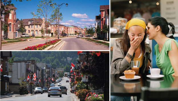
One of the main themes throughout the plan is the desire to concentrate growth and development in key areas through the region. This will be done through the further development of a series of centres and corridors, meaning new downtowns in Markham, Newmarket, Richmond Hill and Vaughan. The idea is that by building more intensively in these areas, there will be less pressure for growth in the existing communities.

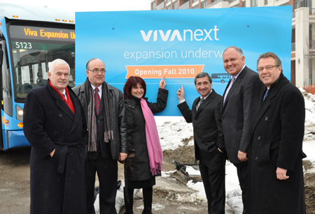
These new multi-use centres will be connected by transportation “corridors” that will make it easier for people to get around the region. And obviously, the best way to travel will be on the vivaNext rapidways, which will run along the corridors and connect the centres.

As they develop, the centres will become focal points for exciting new destinations, offering more choices in entertainment, dining, shopping, and other kinds of attractions. They will also provide higher density housing in condominiums and apartments, for people who like the idea of living at the centre of the action. These new downtowns will be designed with people in mind: they will include attractive, public open spaces where people feel welcomed, and be designed in ways that encourage walking, cycling and transit use.

The Official Plan recognizes that while many people may like the idea of heading to one of the newly urbanized centres to dine out, to shop, or to go to work, they may also want to have a home in a quiet residential neighbourhood. So the Official Plan directs that those kinds of communities will be protected from the kind of intensification that will be used in the centres, so people can continue to enjoy the lifestyles they already have.

And because people in York Region value the greenspaces that make up such an important part of this area, a full 69% of the Region’s landmass will be protected as either Greenbelt or Oak Ridges Moraine.

The Official Plan goes into a lot of detail on these main themes, as well as a range of others, and is well worth reading to give you a sense of how your Region is going to manage growth into the future, and how it is going to evolve.

I like to think that with this well-thought-out plan, people in York Region will truly be able to have it all: our familiar communities will be protected, but we’ll get the benefits of city-building; and we’ll have a great rapid transit system to move us easily between all sorts of exciting new destinations. We’d love to hear your thoughts on this future vision, and what it will mean for you and your family!

Categories
Live-work-play Urban Planning

Sand castles and city building

sandcastles-and-city-buildng_2010_04_29lRemember when you were a kid in a sandbox, and you could have endless fun with sticks and pebbles, building imaginary cities and towns, with houses, stores, roads and schools. You would make sure your city had everything people would want (including great rapid transit to zip people from the drawbridge to the castle), everything would be perfectly organized, and nothing would be too far away.

Believe it or not, there’s a grown-up version of that same activity, with the not-so-catchy title of Land Use Planning. Although you may never have heard this term, land use planning affects every aspect of life in your community today, and how you will be living your life in the future. And one of the most direct ways land use planning affects you, is through your municipality’s official plan.

Every municipality in Ontario must – by law – have an official plan, which has to correspond to plans already established by more senior levels of government. For example, York Region’s Official Plan has to fit within the overall Growth Plan for the Greater Golden Horseshoe, and York Region’s municipalities’ plans need to fit within the overall Regional plan.

Official plans are updated every few years, based on much discussion and public consultation. Just like the sand-box version, official plans identify which parts of town will be where people will work, which ones will be for housing, and which might accommodate both. Working with provincial rules, such as those set out in the Greenbelt Act and Places to Grow, official plans identify which parts of town will grow and which ones will be protected from growth. They identify the main roads, how much traffic those roads can carry before gridlock brings them to a stop, and where transit services will be needed to move people around.

(Hint – York Region’s current Official Plan, which I want to talk about more in my next blog, calls for a heavy expansion of rapid transit across the Region to help us cope with growth – which is why implementing our vivaNext plan is such a high priority for York Region).

Official plans also reflect the values and priorities shared by the community, such as a concern for the environment, or the need for a range of housing choices. An official plan reflects and shapes its community, and provides a road-map for how the community is going to grow – and respond to growth – into the future.

Of course, planning a real-life community is a huge responsibility that can affect the day-to-day lives of thousands or even millions of people. So getting it right is important, and takes a long time and a great deal of care; after all, unlike the sand version, redoing an official plan takes more than a sweep of a shovel. Hearing from the public is a critical part of developing an official plan – York Region’s current plan has a whopping 1,500 page appendix of submissions from the public!

So next time, let’s look at York Region’s December 2009 Official Plan, which highlights the importance of increased rapid transit for the York Region of the future. In the meantime, I’d love to hear from you: if you could go back to the sandbox, what would be in your perfect sand-city?

Links –
Ontario Ministry of Municipal Affairs and Housing Citizens’ Guides to Land-use Planning

Ontario Professional Planners Institute

Categories
Live-work-play Urban Planning

York Region: the need for a fine balance on growth

We have been talking about smart growth, and what is needed to ensure growth doesn’t change our communities in a negative way. One of the most critical needs is to have great transit in place, before the growth really happens.

At a recent community event, someone asked me: instead of worrying about smart growth, why don’t we just say “no”, and cap the size of our towns and cities the way they are, so they won’t change? Wouldn’t that solve our problems?

Unfortunately, there’s no such easy answer. To explain, here’s a mini-lesson on Ontario and York Region planning – for those of you who would like to read more, I’ll attach some interesting links at the bottom.

Planning for growth is a fairly complicated study of demographics, economic and employment patterns, development, and other trends and data. When it’s all put together, based on past patterns, planners are able to predict future populations and where people are likely going to be living and working. In this way, Ontario and York Region planners have forecast that in 2031 over 1.5 million people will be living in York Region and its communities; that’s up from just over 930,000 in 2006.

With those predictions and similar ones from other regions, the Province – in its Growth Plan for the Greater Golden Horseshoe – instructed regions and municipalities to be ready to have much bigger populations. That means those municipalities need to plan for enough housing, schools, hospitals, roads, and transit – and everything else people expect from their community. And because the Growth Plan stems from a piece of legislation, it’s not as if municipalities can just ignore it – it’s the law.

The challenge for the Region and its municipalities is to find ways of accommodating all these new residents, in ways that don’t change the existing character of our communities; to leave intact the things that made us want to move here in the first place.

Obviously, finding a solution to this is complex, with many variables to consider, and the final picture will take multiple decades to come to life. But York Region’s planners believe they have found a balance, with rapid transit seen as one of the keys to make it happen.

Some interesting links –

Categories
Announcements Press Rapidways

Rapidway construction begins in York Region on Enterprise Drive!

Today, an on-site ceremony was held on Enterprise Drive in Markham to commemorate the start of 70 kilometres of vivaNext rapidway construction in York Region.

VivaNext – York Region’s plan for the next generation of rapid transit – includes a network of several rapidways across the Region. They are the east-west Highway 7 rapidway from Highway 50 in Vaughan to Reesor Road in Markham, the north-south Yonge Street rapidway from the Richmond Hill Centre Terminal in Richmond Hill to Green Lane in Newmarket, and the east-west Davis Drive rapidway from Yonge Street to the Southlake Regional Health Centre in Newmarket.

The rapidways will take Viva vehicles out of mixed traffic and into their own dedicated lanes, where they will safely speed past congestion, no matter what time of day.

The 800 metres of rapidways being built on Enterprise Drive, between Warden Avenue and Birchmount Road, are part of the Highway 7 rapidway project.

“This construction phase is truly significant, as it marks the beginning of a new stage of rapid transit in York Region,” said York Region Chairman and CEO Bill Fisch. “Together with the Government of Ontario, we are building a modern transit system to ensure we keep pace with the planned growth in York Region and preserve the quality of life our residents have come to expect.”

Rapidway construction on Enterprise Drive, which will be completed by the end of 2010, will involve the installation of concrete platform foundations, curbs, and the placement of station canopies. No road closures will be required; only short-term temporary lane closures.

“This is great news for the people of York Region and the GTA,” said Markham-Unionville MPP Michael Chan. “The project signals the start of a faster, more convenient rapid transit network that will enable people to get around more easily, improve the ability of our businesses to grow and succeed and help improve the environment.”

As construction of the rapidways gets underway, we encourage you to add vivanext.com to your list of favourite websites for quick and easy access to the latest information and construction updates. While there, you can also sign up to receive our quarterly e-newsletter in your Inbox, along with customized email updates about vivaNext projects of particular interest to you.

Categories
Live-work-play Urban Planning

Montreal tops list of “9 Great Streets Around The World”!

Crowds pack Boulevard Saint Laurent during a street festival. Photo courtesy of Djof.

Project for Public Spaces (PPS), an internationally-recognized non-profit organization that helps communities get the most out of their streets, both as transportation links for all modes of commuters and as vital places for people to enjoy, recently compiled its list of “9 Great Streets Around The World”.

Affectionately known as “The Main”, Montreal’s Boulevard Saint Laurent tops PPS’s list for a number of reasons including its Access & Linkages, Comfort & Image, Uses & Activities, and Sociability.

With vivaNext, this kind of placemaking will also take place along York Region’s busiest corridors as people come to live, work, shop and play in close proximity to great transit service. In addition to great access, vivaNext will bring attractive boulevards, planted medians and an enhanced pedestrian experience including continuous, wide sidewalks.

We wouldn’t be at all surprised if Highway 7, Yonge Street and Davis Drive top the PPS list of great streets in years to come!

Categories
Announcements Press Stations Subways

The Spadina subway extension moves forward!

From left: Vaughan Mayor Linda Jackson, Ontario Minister of Transportation Jim Bradley, Toronto Mayor David Miller, Federal Minister of Finance Jim Flaherty and TTC Chair Adam Giambrone begin the work on the Spadina subway extension.
From left: Vaughan Mayor Linda Jackson, Ontario Transportation Jim Bradley, Toronto Mayor David Miller, Federal Finance Minister Jim Flaherty and TTC Chair Adam Giambrone begin work on the Spadina subway extension Friday.

This past Friday, November 27, 2009, a groundbreaking ceremony of a link that will connect the future Spadina subway extension mainline to the existing Wilson Subway Yard and expand yard storage facilities was held.

Government dignitaries in attendance at the Wilson Yard connection site included the Honourable Jim Flaherty, Canada’s Minister of Finance; the Honourable Jim Bradley, Ontario Transportation Minister; His Worship David Miller, Mayor of Toronto; Her Worship Linda Jackson, Mayor of Vaughan; and Toronto Transit Commission chair Adam Giambrone.

“This is another significant step forward that will help meet the Greater Toronto Area’s future network needs,” said York Region Chairman and CEO Bill Fisch. “As York Region continues to grow and mature, it is imperative to have the proper infrastructure and resources in place for both residents and businesses today and in the future.”

Extending from the Downsview Station in Toronto to the Vaughan Metropolitan Centre Station in Vaughan, the Spadina subway extension will cover a total of 8.6 kilometres and include six stations. Every day, almost as many people travel north to York Region from Toronto as vice versa — including many of the 50,000 students and staff who study and work at York University.

The completion date for the Spadina subway extension is 2015. The $2.6 billion funding required for the project has been secured from all levels of government including $697 million from the Government of Canada, $870 million from the Province of Ontario, $352 million from York Region and $526 million from the City of Toronto.