Categories
General Rapidways Stations Uncategorized Urban Planning vivaNext.com

Glossary of construction terms

Construction can be chaotic for the layperson with its oddly shaped machines digging, drilling and moving around dirt, concrete and other large items. It can be hard to understand what they’re doing exactly, but things can get even more confusing when construction terminology gets thrown around. To help anyone who might be interested we’ve compiled a list of our most often used terms, just for the fun of it –

Abutment A structure located at the ends of a bridge, where the bridge slab adjoins the approaching roadway.
   
Archaeological Testing/Assessment The examination of limited areas for the purposes of identifying historical artifacts. We do this work to meet the requirements of the 2007 North Yonge Street Corridor Public Transit Improvements Environmental Assessment, which identifies areas of potential archaeological interest along the Yonge Street corridor, so that we can ensure any important historical artifacts are identified before the roadway is widened for the rapidway.
   
Backfill Material used to replace, or the act of replacing material, removed during construction. Also, may denote material placed, or the act of placing material, adjacent to structures.
   
Bore Holes Drilling into the ground to bring up samples of earth for testing.
   
Boulevard A strip of grass between a sidewalk and a road, located above a curb.
   
Bridge Pier A supporting structure at the junction of connecting spans of a bridge.
   
Caissons A cylindrical concrete foundation that penetrates through soil to rest upon an underlying stratum of rock. Or the structural support for a type of foundation wall.
   
Canopy A curved glass and steel structure over a vivastation platform that shelters passengers.
   
Cast-in-Place A construction of forms filled with concrete at the final location.
   
Catch Basin A receptacle for catching water runoff from a designated area; usually a shallow concrete box with a grating and a discharge pipe leading to a plumbing or stormwater system.
   
Cofferdam A watertight steel enclosure from which water is pumped to expose the bottom of a body of water and permit foundation construction.
   
Corridor Area where vivaNext has construction underway – e.g. Highway 7 East, Highway 7 West, Davis Drive or Yonge Street.
   
Culvert A drain pipe or small bridge for drainage under a road or structure.
   
Cut and Cover A method of tunnel construction that involves digging a trench, building a tunnel, and then covering it with fill.
   
Daylighting The process of exposing buried utility lines to daylight.
   
Directional Drilling Drilling sideways under structures, roadways, streams, etc. to place pipes, utility lines without excavation and generally limited to less than 30cm in diameter.
   
Duct bank Groups of conduits designed to protect and consolidate cabling to and from buildings. Data and electrical cables are laid out within PVC conduits and bundled together; these groupings of conduit are protected by concrete and metal casings. Duct banks are often buried, allowing contractors to consolidate the wiring for a building into centralized underground paths.
   
Easement An interest in land owned by another that entitles its holder to a specific limited use.
   
Environmental Impact The effects a project will have upon the environment, especially the human environment.
   
Environmental Testing Is used to verify if a piece of equipment can withstand the rigors of harsh environments.
   
Excavator Generally tracked vehicle with rotating body and front mounted digging arm.
   
Geotechnical Testing The process of boring, sampling, and testing the soil at various depths to enable the geotechnical engineer to discover and analyze characteristics of the soil.
   
Guy Wires A wire used to secure a tall exterior mast, antenna, or other structure in place.
   
Hoarding A temporary wooden fence around a building or structure under construction or repair.
   
Hydrovac A large truck-mounted vacuum used to bore holes to locate underground utility cables and pipes.
   
Locates Markings that locate underground infrastructure, identified as follows:

  • Red – Electric power lines, cables and conduit systems and lighting cables
  • Yellow – Gas, oil, steam, petroleum, gaseous or dangerous materials
  • Orange – Communications, cable television, alarm or signal lines, cables or conduit systems
  • Blue – Water, irrigation and slurry lines
  • Green – Sewer and drain lines
  • White – Route of proposed subsurface line or location of proposed excavation
  • Purple – Reclaimed water
  • Pink (fluorescent) – Temporary construction project site survey markings and survey monuments.


Man Hole A hole through which a person may go to gain access to an underground or enclosed structure.
   
Precast (PC) Piles A reinforced concrete pile which is moulded in circular, square, rectangular or octagonal form.
   
Pile Driver A noisy machine that repeatedly drops a heavy weight on top of a post-like foundation until it reaches solid soil, rock or cannot be pushed down any farther.
   
Potholing A small, steep-sided hole usually with underground drainage.
   
Rapidway Dedicated lanes for viva rapid transit down the centre of the road [except on Enterprise Drive, where the lanes are beside the road].
   
Re-bar Ribbed steel bars of various sizes used to give concrete strength in tension.
   
Sheet Piling Planking or sheeting made of concrete, timber, or steel that is driven in, interlocked or tongue and grooved together to provide a tight wall to resist the lateral pressure of water, adjacent earth or other materials.
   
Storm Sewer A sewer used for conveying groundwater, rainwater, surface water, or similar non-polluting wastes.
   
Test Pitting An excavation made to examine an existing foundation, or to determine whether an area is suitable for building construction; includes the taking of soil samples and the determining of the depth of groundwater.
   
Transformer A device that changes, or transforms, alternating current from one voltage to another.
   
Vaughan Metropolitan Centre (VMC) Area around Highway 7 West in the City of Vaughan designated as a new development area.
   
Vivastation A bus rapid transit station on a vivaNext rapidway. Includes a platform in each direction, like a train station.
   
Water Main Water supply pipe generally located at the street level which may supply a number of buildings.


Categories
Construction Going Green Live-work-play Rapidways Stations Urban Planning vivaNext.com

Working together to achieve transit success

You have heard us talk a lot about growth at vivaNext.  Managing growing communities and planning for the future are always top of mind. As the region that comprises nine local municipalities and is home to 1,084,000 residents, 29,000 businesses and 495,000 employees, York Region is the fastest growing region in the Greater Toronto Area. We are always striving to identify key opportunities to improve upon and expand rapid transit plans to support the Region’s increasing population.

The successful execution of the vivaNext rapid transit plans rely on collaboration. While collaboration seems like a long word that has enough syllables to leave you tongue-tied, to me the definition is simple – working together as a team. At vivaNext we strive to work hand in hand with all our stakeholders and neighbours. With open dialogue and information exchange we do our best to listen and address comments and concerns.

Our rapidways are being built along the Region’s busiest corridors where urban development is taking shape. Check out a few municipal videos showcasing local growth.

VivaNext is proud to be bringing York Region an exceptional transit system that will connect it to the Greater Toronto and Hamilton area.

Categories
Construction Live-work-play Rapidways Urban Planning vivaNext.com

The Growth Plan

York Region is growing and vivaNext is the plan to bring the next generation of rapid transit to service that growth. Funding has been granted for several projects within the plan, including bus rapid transit [BRT], a subway, a bus maintenance facility and bus terminals. But where does that plan start? In general, it starts with vision, professional expertise, time, money and a commitment to stick to the plan.

But to be more specific, like all really important initiatives, the starting point for a successful transit program is doing in-depth planning to assess the Region’s population trends, long-term growth forecasts, transportation and development patterns, and economic development goals.

The overall need for rapid transit and the specific projects that together make up vivaNext were first identified in the Region’s Transportation Master Plan, then thoroughly evaluated through a series of Environmental Assessments.

Consultations with approval agencies, such as conservation authorities and local heritage committees, as well as the broader community, including employers, ratepayer groups and chambers of commerce, also provided important input.

This multi-year planning process has involved many levels of professional expertise within and affiliated with York Region and our local municipalities, and is proof of our communities’ long-range stewardship to meet our future needs.

Once the planning is complete then the work of building the transit network begins. Work that requires a logical and disciplined approach, to identify which pieces need to be built first, forming the network’s backbone, and which components can come later. Construction also has to be carefully staged, to minimize the disruption to communities, businesses and travelers.

That logical progression has informed how we’re staging the construction of vivaNext, with the added complexity of planning for the greatest amount of connectivity between our network and the larger GTA transit network as it expands.

Our overall priority is to improve the transit network at every step, so that we all can benefit right away from having more transit choices and a welcoming streetscape.

All currently funded segments will be completed by the end of 2018. But that won’t be the end  – with vivaNext’s established success in delivering projects as planned, we hope to obtain new funding to complete the remaining segments of the network, including additional rapidway segments and the extension of the Yonge Subway to Highway 7.

Categories
General Urban Planning

The power of development

What’s the significance of a pole? In the past few years some of York Region’s towns and cities have been talking about whether or not to bury hydro lines. We’re designing and building rapidways in key urban areas, so naturally the topic of hydro poles and lines comes up when we bring forward new pedestrian-friendly, attractive streetscapes.

Understandably, most people would like hydro lines to be buried, rather than hung from hydro poles. Burying hydro lines is a major project though, and so deserves careful consideration. The cost of relocating lines underground all at once can be up to 10 times the cost of keeping them above ground. That’s not to say that it isn’t worth the money, but it is a big investment.

We support municipalities in their efforts to bury hydro lines, and we also understand why it can’t always be done all at once. Most urban planners agree that hydro poles can be buried over time as a natural result of development and growth, and this is how it could happen:

  • We build rapid transit in key growth areas, attracting people to the added convenience and pedestrian-friendly environment.
  • Where there are people moving in, there will likely be development.
  • When developers build new buildings, hydro lines are often buried as part of the project, either by their own choice or by local zoning regulations.

Regardless of whether hydro poles are buried or not, we’re designing modern streetscapes along the viva corridors. Where hydro poles are being replaced as part of our rapidway projects, we make poles as attractive as possible using special finishes and features. In some cases we use poles that don’t need guy wires, and higher poles to minimize the appearance of the wires. Wherever possible, we bury telecommunications and fibre lines, reducing the number of wires on new hydro poles.

Urban planning is full of important decisions, and the rapidway designs include innovative ideas, while building great neighbourhoods for future generations.

Categories
General Live-work-play

The vivaNext generation

Construction on vivaNext projects is moving full speed ahead. As structures are built and roads are widened, visions of the future are becoming a reality. The promise of the next generation of York Region’s rapid transit is coming to life.

Here at the vivaNext office, we have also welcomed a next generation, with two new summer students joining our communications team. They both have grown up in York Region, one hailing from Newmarket while the other is from Vaughan. Each of them has lived in the Region for over twenty years, so they know how it has changed over time. Both are looking forward to being a part of the team that brings York Region into its next era.

I hope that excitement like this spreads to all generations. I see the vivaNext generation as people of all ages, who use the vivaNext transit system as a way to travel to modern, urban destinations inside and outside of York Region.

For people in Vaughan, the Vaughan Metropolitan Centre (or VMC) will be a new downtown. As a hub for transit, business, shopping, and recreation, the VMC will offer a site for all ages to come together and experience York Region. Our summer student, Alanna, mentioned that she is thrilled about the opportunity to have a “downtown experience” closer to home.

John, our summer student from Newmarket, is looking forward to a highly improved Davis Drive for York Region residents. With pedestrian-friendly boulevards and easy access to places to shop, work, and relax, Davis Drive will become a new destination for the next generation of vivaNext travellers.  

Taken together, these individual projects connect into the vivaNext plan for a seamless rapid transit network, making it easy to travel to work, shopping destinations, and recreation.  

Our projects will benefit everyone who lives or works in York Region, and we want to keep in touch with all of you as these projects are underway. We’re making sure residents are in-the-know with our constant social media updates Be sure to follow us on Twitter and Facebook, and sign up for our e-mail updates.

The future is bright, and the vivaNext generation of travellers has a lot to be excited about.

[poll id=”31″]

Categories
Construction Going Green Uncategorized

Protecting our trees to keep York Region green

Crew works on transplanting trees
Tree buds are an early sign of spring, their canopies are beautifully green in the summer, and we all love their colours in the fall. For many of us, the mature trees on our streets and woodlots are attractive features of York Region’s established neighbourhoods.

So when we develop the rapidway construction schedule and plan, in addition to all the other construction tasks, one of our priorities is to protect and actually increase the number of trees along our routes.

As we design and build our rapidways along Highway 7 and Davis Drive in Newmarket, here’s what we’re doing to take care of the trees we have, and plan for new ones to ensure they continue to thrive into the future.

To start with, we all have a shared commitment to making sure our construction activities minimize impacts to our natural environment. This is a formal commitment that is made early on, in the Environmental Assessments that need to be completed and approved, long before work can begin.

One of our commitments is that our construction activities minimize impacts on trees. At the stage of final design for a rapidway segment, we walk the route with our Arborists to do a careful inventory of all the trees, inspecting each and tagging them, to make sure every tree is included in our construction drawings.

For those trees that are near the construction right-of-way, we look at ways to protect them by installing special protective fencing. We will also look at alternative construction methods where we can to work around a tree, or avoid harming its roots or branches.

For trees that are in the construction right-of-way, we identify any trees that could be safely dug up and replanted somewhere else. Then we work with the local community to identify locations to transplant the trees.

There are some trees that just can’t be saved, either due to a tree’s poor health or other factors. But our commitment is that for every tree we remove, we will replace it with at least one – if not more – new trees.

So this means that once the Highway 7 and Davis Drive rapidway projects are complete, there will be 45% more trees along Highway 7 East and nearly 27% more trees along Davis Drive. Highway 7 and Davis Drive will each be significantly greener when we’re done, and all in all, this adds up to more spring buds, and more fall leaves, for us all to enjoy in the future.

Categories
Construction Going Green Urban Planning

New technology takes root: helping trees grow

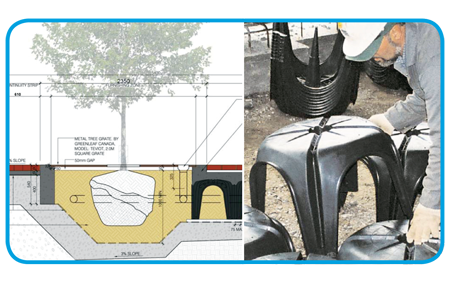
Diagram and photo of Cupolex

Among the beautiful benefits of the vivaNext project will be the improvements we’re going to make to the streetscape along York Region’s key corridors. A key part of those improvements will be carefully planned landscaping, including street trees planted at regular intervals for beauty and shade. Ensuring those trees survive in a tough urban environment is always a challenge, which is where science and technology come in.

Fortunately, our Landscape Architects are up to the challenge, and have tricks up their sleeves to keep our trees healthy and growing strong. To begin with, choosing the right tree is critical. Street trees, especially ones along roads carrying a lot of fast-moving traffic, need to be the kind that can stand up to salt spray and pollution from vehicles. Street trees also need to be relatively drought tolerant, and able to thrive without daily maintenance.

To meet these needs, our Arborist and Landscape Architects focused on a range of hardy trees, including different types of gingko, oak, maple, common hackberry, Kentucky coffee tree, ornamental pear and elm.

Once they’d solved the issue of which trees to plant, Landscape Architects turned to the other big problem facing urban plantings: large trees need a lot of soil around their roots. In a boulevard, there’s only so much room for soil, so trees generally don’t have the underground space they need to grow strong roots and take in nutrients. Our team is using an ingenious solution called “soil cell technology.” This refers to the cutting-edge approach of constructing a rigid form underground that can be filled with soil and then covered up by sidewalks or even roads.

Our soil cell technology is called Cupolex®, and was originally designed as a technique to provide a solid underground framework for ductwork and cables. At first glance it looks like a plastic patio table, with hollow legs at each corner. A series of these patio tables are installed underground, with their legs interlocking, forming a large honeycomb shape – a soil cell – surrounding where the tree will be planted. Then concrete is poured into the legs and over the top, creating a hard, self-supporting shell strong enough to support the weight of vehicles. The boulevard and sidewalks are constructed right over top, with openings left for planting trees. Special access hatches and irrigation pipes are installed for future tree maintenance, and then nutrient-rich soil is blown in, and trees are planted in the openings.

We’re not talking a regularly sized planter full of soil: each soil cell holds at least 16 cubic metres of soil. And each cubic metre is about the size of a stove, so imagine 16 stoves worth of soil for each tree! A typical dump truck holds 8-10 cubic metres, so each tree is going to get more than a dump truck of soil. That’s a lot of soil, and it’s really going to help our trees’ survivability.

Our vivaNext pledge is to do the best planning now, for a beautiful and functional rapid transit system and streetscape. Creating healthy, strong trees that can be enjoyed for generations is part of that, and it’s something we can all be proud of.

Categories
Rapidways Urban Planning

Hello Markham…here comes your rapid transit

Rendering of the future Highway 7 rapidway

We’ve all seen examples of where a transportation system has caused a town to grow. Historically, many Ontario towns grew because they became a stop along a railway line. This was true for Markham in the late 1800s, when the Toronto and Nipissing Railway Company began stopping at stations in Markham and Unionville. Another cause for Markham’s growth was the post-Second World War baby boom and migration to the suburbs, and the building of Highway 404 in the mid-1970s. With the influx of high-tech industries, among other changes, Markham has seen an astonishing 25% population increase between 2001 and 2006, ranking Markham as one of the fastest growing municipalities in Canada.

Transportation plays a key role in growth and development, and Markham needs a system to help move the current and future population from place to place. VivaNext is building a rapid transit system along Highway 7 to give people a better transit infrastructure that will accommodate the current population and allow for future growth. As well as move people efficiently, rapidways encourage the development of transit-oriented and pedestrian friendly places to live, work and play. As you can see in the photo above, Markham’s rapidways will widen Highway 7 by two lanes and include two centre lanes dedicated to Viva vehicles and flanked by attractive architectural features and landscaped boulevards.

We’ve already started preparing for construction along Highway 7 in Markham by relocating hydro poles and other utilities to allow for road widening. If you’re interested in receiving construction bulletins and invitations to public meetings, be sure to sign up for updates.

When the snow melts you’ll see road construction begin along Highway 7, and we hope you’ll see past the short-term inconveniences and construction to the more welcoming, improved Highway 7 in Markham.

Categories
Live-work-play Rapidways Urban Planning

Why “TOD” is great news for all of us

A rendering of transit-oriented development in Markham
A rendering of transit-oriented development at the future Markham Centre

Recently, I wrote about transit and the role it has in shaping communities, in particular, the development that tends to spring up along transit routes and around stations. This time, I want to talk more about what we mean by “transit-oriented-development” ( TOD for short), and why this kind of development will be good news for people in York Region—whether or not they are transit users themselves.

Most people get around York Region by car – possibly because they want to – but also because some people find it challenging to do all the things they need to do in a day by transit. That’s not surprising in a region like this one; in communities where development has been shaped by a long-standing car culture, destinations are more likely to be spread out, with greater distances between live-work-play destinations. Even the design of buildings may be shaped by car usage, with large parking lots separating buildings from roads.

The idea behind TOD is that people using transit are also likely to be pedestrians at some point during their journey – either at the beginning, or the end (or both). Studies have shown that people are willing to walk about 5 minutes to or from transit, which is somewhere between 400 and 600 metres. So TOD uses the approach of creating a complete community within walking distance of transit – including workplaces, homes, shopping, recreation and services. The thinking is that if new developments are designed to be conveniently compact and appealing to pedestrians, people are more likely to leave their car at home for at least one of their trips. Obviously, the good news is that more people taking transit means fewer cars on the road, less pollution, and less gridlock.

So York Region planners have linked the plans for the vivaNext rapidways to land use policies that will result in more TOD along Viva routes and near vivastations. These policies will likely mean that much of the new development built around vivastations will be compact and mixed-use, providing housing, employment, retail, dining, services and recreation, all within a walkable distance of transit. Developments will also include more welcoming public spaces, attractive landscaping, and other amenities so that people enjoy being out and about.

How will this affect you? In a pre-TOD scenario, a typical day could start with a drive to work, then a drive to a restaurant for dinner, ending with a drive to a movie or concert before driving back home. With more TOD, you would have the choice of taking transit to work, then walking around the corner from the office to dinner, then strolling across the street for a show before grabbing a coffee and getting home again by transit. Same day, two different ways of getting around.

The point is that transit and TOD don’t have to change the way people live in York Region, but it will give us all more choices – in what we do, where we do it, and how we get there. We think that’s good news for everyone.

Categories
Live-work-play Urban Planning

Seeing into the future with York Region’s Official Plan

futurebuilds

What’s the best way to see what the future will look like for York Region? A crystal ball? Cards? Tea-leaves?

In all seriousness, when it comes to reading the future for our community, I suggest you look at York Region’s Official Plan. This document, which is a critical planning tool, has a number of functions: it’s a public document used to describe and promote our vision for the future, but it is also a legal document used to support and defend key decisions related to public infrastructure, development and growth.

Based on a 25 year planning timeframe but updated every five years, York Region’s Official Plan sets out several key themes which will guide planning decisions, and will help make growth work for us.

One of the main themes throughout the plan is the desire to concentrate growth and development in key areas through the region. This will be done through the further development of a series of centres and corridors, meaning new downtowns in Markham, Newmarket, Richmond Hill and Vaughan. The idea is that by building more intensively in these areas, there will be less pressure for growth in the existing communities.

These new multi-use centres will be connected by transportation “corridors” that will make it easier for people to get around the region. And obviously, the best way to travel will be on the vivaNext rapidways, which will run along the corridors and connect the centres.

As they develop, the centres will become focal points for exciting new destinations, offering more choices in entertainment, dining, shopping, and other kinds of attractions. They will also provide higher density housing in condominiums and apartments, for people who like the idea of living at the centre of the action. These new downtowns will be designed with people in mind: they will include attractive, public open spaces where people feel welcomed, and be designed in ways that encourage walking, cycling and transit use.

The Official Plan recognizes that while many people may like the idea of heading to one of the newly urbanized centres to dine out, to shop, or to go to work, they may also want to have a home in a quiet residential neighbourhood. So the Official Plan directs that those kinds of communities will be protected from the kind of intensification that will be used in the centres, so people can continue to enjoy the lifestyles they already have.

And because people in York Region value the greenspaces that make up such an important part of this area, a full 69% of the Region’s landmass will be protected as either Greenbelt or Oak Ridges Moraine.

The Official Plan goes into a lot of detail on these main themes, as well as a range of others, and is well worth reading to give you a sense of how your Region is going to manage growth into the future, and how it is going to evolve.

I like to think that with this well-thought-out plan, people in York Region will truly be able to have it all: our familiar communities will be protected, but we’ll get the benefits of city-building; and we’ll have a great rapid transit system to move us easily between all sorts of exciting new destinations. We’d love to hear your thoughts on this future vision, and what it will mean for you and your family!