 If you’re like me, traffic signals are one of those things that you automatically respond to without spending a lot of time thinking about them – if a light’s green it means you can go, and if it’s red you can’t. But when something is new, sometimes it helps to understand the reasons behind it. We’ve introduced new traffic signals on Highway 7 at the Leslie and West and East Beaver Creek intersections in December 2011, and want everyone to understand why they’re there and how they work.
As part of the vivaNext plan, rapidway lanes are being built in the middle of the road, making it much wider than it was in the past. The widening for this section of Highway 7 is now complete, so we’ve installed the new traffic signals at three of the intersections.
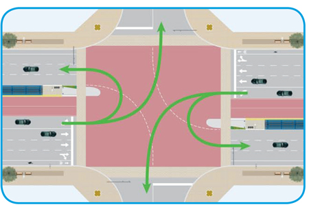
The new traffic signals include a protected left-turn arrow, which only allows left turns from Highway 7 when the left-turn arrow is green. During the left-turn arrow signal, there is no straight-through traffic in either direction and no pedestrian crossings allowed.
The reason for installing the protected left turn arrow is because of the increased width in the road. With the rapidway running down the middle of the intersection, the left turn lanes aren’t opposite each other. The protected left-turn arrow allows left-turning traffic to turn without the hazard of oncoming traffic.
When the protected left-turn arrow is lit, drivers in the left-turn lane can also make a u-turn in the intersection. In sections of road with rapidway lanes in the centre, drivers will access addresses or streets on the opposite side of the road by making a u-turn at an intersection. Intersections with the new traffic signals have a special “U-Turn Permitted” sign under the “Left Turn Signal” sign.
During construction, video detectors will sense traffic in the dedicated left-turn lanes and extend the duration of the left-turn arrow. Once construction is complete, a magnetic sensor known as a “loop” will be installed in the pavement to detect traffic and extend the left-turn arrow duration.
At times, it might take a bit longer to drive through an intersection that has the protected left-turn arrow, but overall, our corridors are changing for the better. As our population grows, Highway 7 will become increasingly urbanized (see our blog about how Highway 7 is changing), and Yonge Street and Davis Drive will follow, each with their own local character. Instead of feeling like highways designed for cars, each street will feel like an urban area, with interesting destinations. The new traffic signals will be there to ensure drivers and pedestrians can navigate safely to their destination.
Diagrams of intersection traffic patterns:
Six-lane road, like Highway 7
Four-lane road, like Davis Drive
Diagrams of u-turn traffic patterns:
Six-lane road, like Highway 7
Four-lane road, like Davis Drive
