Categories
Community Events General Live-work-play

pick a park, any park …

pick a park, any park ...

The summer months are often a chaotic time of year when it comes to finding fun, convenient activities that the whole family will enjoy.  This summer, let us help you plan the perfect outing.

Summers in the towns and cities of York Region provide residents with perfect places to spend time outside. Whether it’s picnics, playgrounds, fishing, or just good old fresh air and sunshine, York Region’s parks are an outdoor oasis.

Newmarket’s Fairy Lake

Fairy Lake is a staple location for Newmarket fairs and festivals throughout the summer months. Located just south of Newmarket’s Historic Main Street, this park serves as an urban greenspace in the heart of the town. Featuring playgrounds, gazebos and easy access to the Farmer’s Market at the Newmarket Riverwalk Commons, there is something for everyone. The new Viva service drops you off right at the top of Main Street for easy access.

Vaughan’s Chancellor District Park

Located in Woodbridge, just off of Ansley Grove Road, Chancellor District Park is a go-to greenspace in the community. Outfitted with an outdoor splash pad as well as a playground, this park is an ideal place to take children of all ages to for a day of outdoor fun. On August 3, 2016, this park is hosting a Michael Jackson tribute concert as part of the City of Vaughan’s Concerts in the Park series. If you see our vivaNext booth at a Concert in the Park, be sure to drop by and chat with us!

Markham’s Milne Dam Conservation Park

Located just off of Highway 7 and Markham Road, coming in at 305 acres, Milne Dam Conservation Park is an idyllic place to hike and bike with your family. Featuring 2.3 kilometers of trails running through the forest, a beach area and picnic tables, Milne Dam Conservation Park is the perfect place to immerse yourself in on a sunny day.

Whether it’s the walk in the park after dinner or a concert in the park across town, there are pockets of nature all around the region for everyone to enjoy. So get out your bikes, your picnic blankets and Frisbees because there’s lots of summer left to enjoy and with convenient and fast Viva service ready to take you were you want to go – it couldn’t be easier! Enjoy!

– Sydney Grant, student Public Relations Coordinator

Categories
Construction General

what’s in a sign?

What’s in a sign?

Even with the most careful planning, construction zones pretty much always result in some delays and congestion for commuters, and we know that our vivaNext rapidway projects are no exception. We are committed to doing whatever can be done to minimize the impact of construction and keep people informed.

One way of doing that is to let drivers know if there’s congestion along their route, and if so, how much of a delay they can expect. By giving real-time information, drivers can decide if they should take an alternate route.

That’s why we install variable message signs, or VMS, on the approaches to our construction zones, including along Yonge Street and on Highway 7 near the Vaughan Metropolitan Centre.

Using Bluetooth Traffic Monitoring [BTM] software, these signs show actual travel times, in real time, between specific locations. Roadside sensors collect Bluetooth data from passing cars, and the information is uploaded to a central location. The software then analyzes the data to determine current travel times, which is reflected on the signs. In addition to travel time, project managers can update other information on the signs, such as upcoming work or lane closures.

BTM is able to detect Bluetooth signals emitted from cell phones, tablets and other Bluetooth or Wi-Fi devices on-board, and convert this into accurate information, simply and inexpensively. Not all vehicles carry devices with Bluetooth turned on, but there is a high enough proportion of devices to provide effective information.

Cars emitting Bluetooth signals are randomly chosen as they pass into the defined area.  Multiple sensors placed along the route detect the unique identifier of each Bluetooth signal and track it as it travels through the area. In this way, the system measures in real time how quickly cars are moving, and reports actual travel times. The software has built-in algorithms to make sure it only tracks vehicles while ignoring Bluetooth signals emitted from pedestrians or other stray sources. The information is constantly uploaded to the VMS, telling drivers exactly what’s happening on the route ahead.

The technology to use Bluetooth data to analyze travel times has been around for some time.  But vivaNext was actually the first project in North America and possibly the world, to collect and convert this information for display on variable message signs.

What’s in a sign? We know that the signs on their own won’t reduce the disruptions caused by construction. But by providing drivers with accurate travel time information, they’ll know what to expect for their commute.


Categories
General Urban Planning

automated vehicles >> will transit drive itself?

automated vehicles >> will transit drive itself?

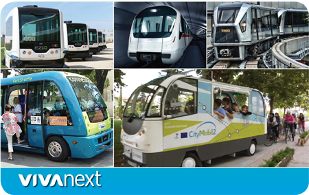
Lately there’s been a lot of news on the topic of automated vehicles. In February, the National Highway Traffic Safety Administration in the US officially stated that an artificial intelligence system [computer] in an automated vehicle can officially be considered a driver. And in at least five global cities, there are driverless buses already on the streets. In aviation, pilots have been relying on auto-pilot for decades when landing and taking off in low visibility, and many people-mover rail systems [such as airport monorails] are automated.

Studies show that, statistically speaking, computers are safer than humans at driving. However, we know that getting from here to there is about more than arriving safely. Comfort is important of course, along with convenience and efficiency or speed. For some, a travel choice is a personal statement – to cycle or walk, to make use of transit, or to drive a certain style of car. Many vehicles already have “driver assistance systems,” with features that brake when an obstacle is detected, and alert the driver when the car in front has moved forward or when the vehicle has left its traffic lane.

So the technology is there, and it’s already being used. The question isn’t whether it will happen, it’s how it will affect how we travel. It will depend on how they’re used – if every individual uses their own automated vehicle, traffic congestion and parking issues will likely remain the same. But if we share vehicles and take transit…our cities and roads could become safer and more efficient.  Interesting topics for discussion and consideration and we continue to follow them with interest.

At vivaNext we’re for mobility – whether this means subway, bus rapid transit, or automated transit in the future, we’re thinking about how York Region’s roads can be prepared and always looking for new and innovative ideas to make improvements.


Categories
General

winter scoop

winter scoop

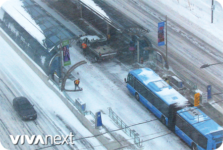
Winter may have been a little delayed this year, but judging from the frigid temperature outside… it’s here. Although our construction crews might not be able to continue to work in this cold weather, some work is still being done. Even in construction areas, winter maintenance and road clearing will still be done throughout the winter months.

All of our rapidway projects are at different stages, either open or underway. Each piece of each project is unique, and detailed designs are refined before we even get started on construction. Then there’s always coordination to be done with utility companies and municipalities, so we work on that ahead of time to help construction go smoothly in the spring. When a project is almost done, there’s a lot of technical testing, plus communications to local residents and commuters throughout the project’s life.

Even when things slow down due to the weather outside, we’re busy inside. Construction management teams are carefully scheduling work for 2016, and designers are completing detailed plans.

As snow falls outside, your local municipality [e.g., Newmarket, Vaughan, Richmond Hill, Markham] will clear the sidewalks, York Region’s Roads branch is responsible for clearing the rapidway lanes [see their video!] and YRT/Viva operations staff look after the vivastation platforms.

We know that everyone wants to know what’s happening, so we’ll be sending out updates regularly. If you’d like to receive announcements and construction notices about work in your area, be sure to sign up for updates.  So… that’s the scoop for this winter – inside and out!


Categories
General Studies

bus rapid transit is a global phenomenon, up nearly 400% in over 10 years

BRT system is a global phenomenon

At vivaNext, we’re working hard to build a Bus Rapid Transit [BRT] system. And we’re not alone! Our vision of fast, reliable and convenient BRT service is shared by many cities and regions, all over the world.

Bus Rapid Transit is a global phenomenon that has nearly quadrupled over the last 10 years, growing 383% worldwide from 2004 to 2014, according to data compiled by the Institute for Transportation and Development Policy.


buses! buses!

Former mayor of Bogotá, Colombia, Enrique Peñalosa, said it best with his rally cry: “Buses! Buses! Buses! Buses!” That was his response to a suggestion that some municipalities might benefit from a subway.

Indeed, for many cities and regions, BRT simply makes sense. A BRT system can be built at a fraction of the cost and time of a rail system – in the span of a few years instead of a decade or more – and still provide service that can be just as reliable, fast and frequent as a train.

More cities and regions are turning to BRT as their transportation solution, with 1,849 kilometres of new lines added globally in the last decade. In York Region, our contribution was the six- kilometre stretch of rapidway on Highway 7 East! And that’s just the beginning.


32 million global BRT riders every day

Around the world, 32 million people ride BRT every day, according to the global database BRTData.org.  That’s 5,087 kilometres of BRT lines in 193 cities.

The undisputed global leader of the movement is Latin America with nearly 20 million passengers, followed by Asia with 8.7 million. Brazil is the birthplace of BRT, and the country with the largest network of systems; nearly 12 million passengers a day in 34 cities!

Bus Rapid Transit grew the most in China with construction of 552 new kilometres over the last decade, followed by Brazil with 345 kilometres, and Mexico with 234 kilometres, according to the Institute for Transportation and Development Policy.

Closer to home in North America, BRT is a small but growing phenomenon with one million passengers in 27 cities. The United States was fourth worldwide in terms of growth, with 104 kilometres of new lanes built in the last 10 years.


9.6 million annual riders on Highway 7 East rapidway

Here in York Region, we’re working hard to bring the vivaNext vision to life. Our current plan will include 34 kilometres of rapidway once construction is complete, connecting the communities of Markham, Vaughan, Richmond Hill and Newmarket. That includes the six kilometres already running in Markham. We’re also forging connections with the Spadina Subway Extension, and advancing plans for the Yonge North Subway Extension. In 2014, our Highway 7 East rapidway in Markham had 9.6 million riders, so we’re well on our way.

We’re building rapidways but the true end product is something much greater – mobility. Mobility makes everything possible. Because BRT runs in designated lanes it’s not subject to the whims of traffic. When our rapidways are complete, people will know they can rely on Viva service to get where they need to go – to work, to school, and to life.  As our communities grow and roads get more congested, our rapidway system will be ready to meet the growing demands of our region – part of a global movement moving people forward into the future


Categories
General

private time on public transit

private time on public transit

The Toronto Star recently ran a piece on how the TTC has become an extension of “home” for its users. While he remarked that some people do things not normally considered polite for public spaces, Urban Affairs writer Christopher Hume also noted that even with less privacy, riders have more freedom.

“Even in a moving subway,” he wrote, “it’s easier to put on lipstick than it is driving on Highway 401. It’s also easier to eat, drink, read and tend to one’s appearance.”

People who use transit regularly use the time in a variety of ways that are either impossible or risky when driving a car. They read books, work on laptops, watch TV, talk to other riders, snooze – and yes, put on makeup or simply stare into space at the end of a busy day.

They don’t worry about being cut off in traffic or being stuck behind a sander during a snowstorm. Parking and finding a gas station are also non-issues, and riders save thousands of dollars a year in car depreciation, gas and insurance. And let’s not forget that they also get tax credits for transit passes like the Viva Monthly Pass.

If you trade your car keys for a transit seat, you might just find yourself with time on your hands!


Categories
General Studies Urban Planning

how transit and city planning work together

how transit and city planning work together

An exciting new urban planning report — Make Way for Mid-Rise: How to build more homes in walkable, transit-connected neighbourhoods proposes actions that would help increase density along transit lines in the Greater Toronto Area. The report was released by the Pembina Institute and the Ontario Home Builders’ Association on Monday, May 4.

The nugget of this report is that the range of affordable housing choices for families would increase by building mid-rise, mixed-use buildings along transit lines. The report argues that mid-rise development supports “healthy lifestyles and local economies, since it can help increase walkability and put more people close to transit, while also supporting local business.”

So, should our communities “make way for mid-rise”? If we want our cities to have a better chance of developing the type of population density that supports a healthy neighbourhood with street life, walkability, and good transit, then, yes!

As the populations of York Region and the Greater Toronto and Hamilton Area increase, it’s the job of government, urban planners, and developers to ensure that the community infrastructure is properly accommodated, and resources like farmland and clean water are protected.

The Make Way for Mid-Rise report presents five ways to support increased density:

  1. Require minimum densities along rapid transit lines
  2. Eliminate minimum parking requirements
  3. Pre-approve mid-rise development along avenues and transit corridors
  4. Require retail planning before mid-rise is built
  5. Make parkland dedication rules more equitable

When transit planning and urban planning work together, the result can be what vivaNext is all about: great cities and great transit, hand in hand.

Take a few moments to check out the report, Make Way for Mid-Rise, and read more about the proposals in the Toronto Star.


Categories
General Uncategorized

connecting the dots

connecting the dots

If you’ve seen the video we posted yesterday, you’ve seen how excited some people can get over great transit. Ok, so it’s a little over the top. It has been exciting though, to see our vision, planning and designs turn into rapidway reality on Highway 7 East in Markham.

Next, rapidways will open on Davis Drive in Newmarket and Highway 7 West in Vaughan, and a rapidway along Yonge Street will help connect the dots [see our project map]. Each project is at a different stage, and together they’ll provide more travel choices and help support our growing population.

If you haven’t been to our website lately, check out the new photo album showing the progress of the Highway 7 East project from beginning to end. And be sure to sign up for updates about our construction projects. They’re great sources of construction information, and you’ll also receive important project announcements, newsletters and open house invitations.


Categories
General

numbers, numbers… how we report progress

numbers, numbers… how we report progress

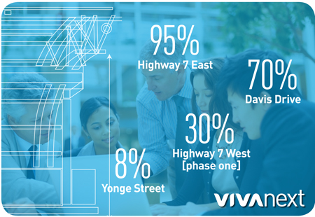
We recently updated the percentages on our website that show how far along each of our rapidway projects are: Highway 7 East is 95%, Highway 7 West [phase one] is 30%, Davis Drive is 70% and Yonge Street is 8%. It might make you scratch your head, since some of these projects appear to be more, or less, advanced than these percentages reflect. And in some cases, progress doesn’t show up in the percentages.

The percentages are updated quarterly, and are based on each project’s budget and how much has been billed. To stay open and transparent about our budgets and project progress, we report these percentages and information about construction milestones to our Board of Directors. Once our quarterly reports are presented to the Board, to Metrolinx, and to York Region Council they’re available to the public [posted here on our website]. There are variations from time to time – for instance, in our most recent report, we reported on the third and fourth quarter of 2014 together because there was no Board meeting in the fall.

As for the progress of each project:

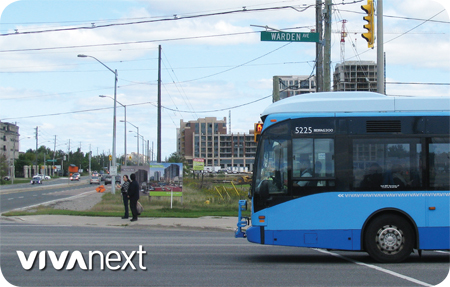
  • The Highway 7 East rapidway is fully in service, and now that the snow is gone crews are completing some top-layer paving and sidewalk/landscaping work near Warden Avenue, taking care of the last 5%.
  • The percentages for the Davis Drive and Highway 7 West rapidway projects didn’t change between the third and fourth quarters of 2014, but as anyone knows who spends time on these roads, crews have been working through the winter and progress has been made [just not reflected in the budget or billing yet].
  • At just 8%, the Yonge Street rapidway is just getting started and for the next several months much of the progress will be with relocating and updating utilities in preparation for road widening.

When working along streets that are heavily travelled, in ever-changing weather, digging into underground infrastructure, there’s always a chance of delays along the way. But by keeping track, and reporting our progress, we can make sure everyone knows how it’s going.


Categories
General

as days get longer…

as days get longer

Days are getting longer, but for the next month or so we’re still travelling to and fro close to dawn and dusk, and right now there are snowbanks at every turn. So visibility isn’t great, but spring is on the way! Things are looking up, and it’s important that both drivers and pedestrians look up to see who’s on the other side of that snowbank, and to see that it’s safe to move forward. Let’s stay in step with those around us by keeping an eye out for one other and being as visible as possible.

On Highway 7 East in Markham and Richmond Hill, commuters might have more of a spring in their step, and it’s not just because they’re looking forward to better weather. Now that the rapidway is open, Highway 7 has many years of fast, convenient transit ahead, not to mention bike lanes and nice wide sidewalks. In some sections of Highway 7 it was truly a highway before construction with only traffic lanes and no sidewalks or bike lanes. Now, everyone has a choice in how they connect from A to B, and that’s something to look forward to.

To better weather, to more choices, and to safe travels throughout York Region!

For some tips on getting around on Viva, check out YRT/Viva’s video about dressing with safety in mind.