Questions
What is opening for service?
How are we delivering rapid transit in York Region?
What is the rapid transit plan for York Region?
What is the status of the Yonge North Subway Extension?
How do drivers reach the opposite side of the road?
Will pedestrians be able to easily cross the street?
How do people get to the vivastation in the centre of the road?
What happens in an emergency on a vivastation platform?
How will drivers know to stay out of the rapidway lanes?
How do Viva vehicles transition into and out of the rapidway using transit priority signal?
Will Viva run in mixed traffic at any point[s]?
How will the rapidways be maintained?
Routes and Fares
What transit can the new rapidway connect to?
Where will the new Major Mackenzie vivastation be located?
How frequent will service be?
How does fare pricing work when transferring between YRT and the TTC?
Can I pay my YRT fare without PRESTO? Can I use cash to buy a ticket?
How do I use PRESTO for my fare?
Are there plans for fare integration between Viva and other transit services?
Why don’t local YRT routes use the rapidway?
How will Viva rapidway service differ from my curbside Viva service?
Cycling
Where can pedestrians and cyclists travel along this section?
How do cyclists make left turns at intersections?
Where do cyclists go once the bike lanes end?
Contacts
Answers
What is opening for service?
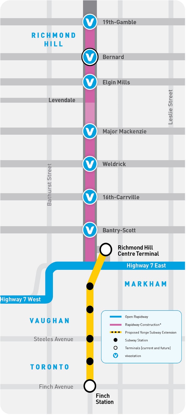
This 6.5-kilometre segment of dedicated lanes for Viva bus rapid transit [rapidway] runs along the existing Viva route on Yonge Street in Richmond Hill, from Highway 7 to Major Mackenzie Drive and from Levendale Road to 19th Avenue/Gamble Road. To preserve the heritage area between Major Mackenzie and Levendale, Viva will continue to drive in mixed traffic as it does now. There will be seven new vivastations in the centre median:
- Bantry Avenue/Scott Drive
- 16th Avenue/Carrville Road
- Weldrick Road
- Major Mackenzie Drive
- Elgin Mills Road
- Bernard Avenue
- 19th Avenue/Gamble Road
How are we delivering rapid transit in York Region?
Yonge Street in Richmond Hill is the final segment of the first phase of York Region’s bus rapid transit network. This first phase includes nearly 34 kilometres of dedicated bus lanes and 38 new stations along York Region’s busiest corridors, representing a $1.8 billion [2017 dollars] transit investment. These rapidways are bringing fast, reliable, comfortable travel options, and are part of a larger return on investment in place for generations to come. As of the end of 2019, over $2.1 billion in assets have been delivered in York Region, including rapidway vivastations and lanes, boulevard work, underground infrastructure, streetscape features, facilities and terminals, and subway infrastructure. Rapidway projects are complete street rebuilds, replacing and updating utilities and infrastructure, like water mains, culverts and bridges, adding bus lanes, and building new tree-lined sidewalks, traffic lanes and bike lanes.
What is the rapid transit plan for York Region?
There are still over 75 kilometres of unfunded bus rapid transit planned for York Region, as well as the 7.4-kilometre Yonge North Subway Extension [YNSE].
York Region’s rapid transit plan goes hand-in-hand with the regional Centres and Corridors Plan, focusing new population growth in urban areas, encouraging walkable, transit-oriented city centres and putting a stop to suburban sprawl. Having fast, convenient travel options in place is key to attracting new residents and businesses. In 2019, nearly half of York Region’s new jobs and 79% of apartment units were located in Richmond Hill, Vaughan, Markham and Newmarket, and employment grew by 5.3% - the fastest growth in 10 years and outpacing job increases in the GTA [3.5%].
Funding for the first phase of bus rapid transit projects was committed in 2009 by the Province of Ontario and was intended to target corridors with the highest transit demand. Over the last decade, York Region has continued to grow quickly, and some routes that were considered secondary then, are now projected to have increased ridership of 300% to 1,100% by 2041.
What is the status of the Yonge North Subway Extension?
The Yonge North Subway Extension [YNSE], from Finch to Highway 7 is the missing link needed to connect the GTA and unlock new businesses and jobs in the Richmond Hill/Langstaff Urban Growth Centre. This project is York Region’s top transit priority and the Province of Ontario has committed to funding their part. Sustained support is needed from all levels of government, including a 40% funding commitment from the Government of Canada. For more information visit vivanext.com/YongeSubwayExt.
How do drivers reach the opposite side of the road?
Rapidways change how drivers access driveways and streets between intersections. The rapidway provides safer left turns for drivers, with dedicated left-turn signals at intersections and the ability to make protected U-turns.
Eliminating mid-block left turns helps to improve the flow of traffic, but more importantly, improves safety. There were 51-74% fewer collisions along completed rapidways in York Region in a 2019 comparison with statistics from the same corridors before rapidways were built.
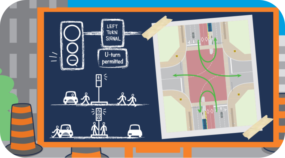
Will pedestrians be able to easily cross the street?
At intersections with vivastations, pedestrians have the option of crossing the intersection in two stages.
There is an area in the middle of the crosswalk with a protective concrete barrier, where pedestrians can push the “walk” button and safely wait for their signal before crossing the second half of the street.
How do people get to the vivastation in the centre of the road?
Pedestrians and cyclists can get to the vivastation by crossing at the intersection crosswalk. A crosswalk push-button is located at the centre of the crosswalk near a protective concrete carrier, to assist people in crossing from the vivastation platform to the sidewalk.
What happens in an emergency on a vivastation platform?
Pushing the emergency call button at any time [24/7] will allow two-way communication with a York Region Enforcement Dispatcher who will focus the security cameras on the emergency call button area. Blue pulsing lights on the platform will also be activated to attract the attention of responders. The transparent glass canopy also provides visibility to passersby, as an extra measure of security.
How will drivers know to stay out of the rapidway lanes?
A number of features ensure the rapidway is easy to see, including red asphalt, “bus only” pavement markings and dotted lines for left-turning traffic in intersections, and raised concrete medians separating regular traffic lanes from the rapidway lanes.
How do Viva vehicles transition into and out of the rapidway using transit priority signal?
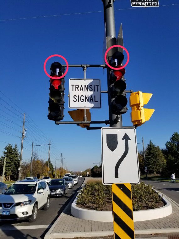
When traveling on Yonge Street, Viva vehicles making a southbound left onto the Yonge Connector Road and traveling northbound through Major Mackenzie Drive, will have a transit priority signal, which means traffic and pedestrians yield to Viva vehicles. At these intersections, there is a round signal on top of the regular traffic signal that shows a vertical white bar. When illuminated, Viva vehicles are permitted to proceed, while all other traffic faces a red light and solid ‘don’t walk’ hand.
Will Viva run in mixed traffic at any point[s]?
Yes, Viva will merge into mixed traffic with curbside stops north of Major Mackenzie Drive to Levendale Road, where Viva transitions back into the rapidway. Where the rapidway ends north of 19th Avenue/Gamble Road, Viva will transition back into mixed traffic again, with curbside stops.
How will the rapidways be maintained?
York Region will maintain the rapidways, traffic lanes and the dedicated bike lanes, York Region Transit [YRT] will maintain the vivastations and the City of Richmond Hill will maintain the sidewalks.
Routes and Fares
What transit can the new rapidway connect to?
Viva blue will use the rapidway on Yonge Street and local YRT routes will continue to use curbside stops.
When the rapidway opens, buses driving south on Yonge from Newmarket Bus Terminal will provide connections to Bernard Terminal and then Richmond Hill Centre Terminal and regional rail at Langstaff GO Station, making connections to bus routes along Highway 7 in Richmond Hill, Markham and Vaughan, and south on Yonge to TTC subway at Finch. In future, it will connect to the Yonge North Subway Extension. Buses headed north on Yonge will connect to Newmarket Bus Terminal, which meets up with the Davis Drive rapidway, offering connections to regional rail at Newmarket GO Station, and to Southlake Regional Health Centre and the Highway 404 Park ‘n’ Ride.
Where will the new Major Mackenzie vivastation be located?
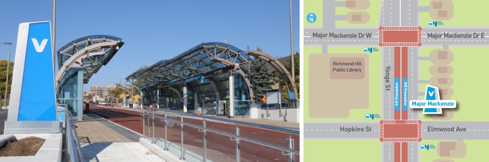
The Major Mackenzie vivastation will be approximately 200 metres south of Major Mackenzie on Yonge, on the north side of the Hopkins Street/Elmwood Avenue intersection. The location south of the Yonge/Major Mackenzie intersection is a result of property constraints and limitations in the area.
The vivastation platforms will be mirrored [side-by-side], with both northbound and southbound vehicles stopping on the north side of Hopkins/Elmwood. Pedestrians will cross at the new signalized intersection located at Hopkins/Elmwood and then travel to their destination. The vivastation name will remain as Major Mackenzie.
When the station opens, there will be wayfinding signage on Yonge and on Major Mackenzie to help guide customers making transit transfers.
How frequent will service be?
The rapidway brings the rapid to Bus Rapid Transit. Viva is already known for being frequent and when the Yonge rapidway opens, schedules will be adjusted to ensure appropriate spacing between arrivals.
Viva and YRT routes are evaluated by YRT’s Service Planning branch on a regular basis, and service changes are made to routes and schedules as needed.
How does fare pricing work when transferring between YRT and the TTC?
York Region Transit [YRT] fare is required when boarding any YRT or Viva bus route.
Customers coming off the TTC subway and onto a YRT bus must pay a separate YRT fare. This can be done using a PRESTO card, the YRT Pay app, or exact cash [on YRT local routes]. Visit YRT’s Fare Chart page for prices. Customers may also purchase a single fare from the One Ride fare machines located inside and outside of terminals.
Customers coming from YRT buses and onto the TTC subway must pay a separate TTC fare. For more information, see YRT’s Fare Policies page.
Can I pay my YRT fare without PRESTO? Can I use cash to buy a ticket?
Yes, you may use exact cash on the local YRT buses, or you may use debit or credit at a One Ride fare machine located on vivastation platforms. Alternatively, you can also pay your fare for a YRT trip using the YRT Pay app. Here is more information about payment options, fares and passes.
How do I use PRESTO for my fare?
PRESTO is the smart card fare option for York Region Transit [YRT] as well as TTC. To use it for your fare, tap your PRESTO card on a PRESTO fare machine and your fare is deducted from your account.
Presto cards can be purchased at select Shoppers Drug Mart locations throughout the Greater Toronto Area [GTA]. Here is more information about PRESTO for YRT and Viva routes. And here is general information about paying with PRESTO: prestocard.ca.
Are there plans for fare integration between Viva and other transit services?
Metrolinx, YRT, and other Greater Toronto and Hamilton Area [GHTA] transit agencies are working toward finding solutions for fare integration.
Why don’t local YRT routes use the rapidway?
In general, the purpose of YRT buses is to provide convenient local service within neighbourhoods with the curbside stops that feed into the rapid transit system and enable customers to get wherever they need to go. Emergency service vehicles and some transit agencies are permitted to use the rapidway lanes at their discretion.
How will Viva rapidway service differ from my curbside Viva service?
Viva rapidway service will offer all the things you already love about Viva on other corridors, with the added benefit of being in your own lane and not being caught in congested traffic. In addition, stations have amenities such as a heated waiting area, enhanced security and live service announcements so your short wait for the next vehicle will be comfortable.
Cycling
Where can pedestrians and cyclists travel along this section?
Pedestrians along Yonge Street will enjoy wider sidewalks, lined with trees and shrubs and cyclists will enjoy street-level and raised bike lanes along Yonge.
From Yonge, pedestrians and cyclists may travel on a shared-use path on the Highway 7-Yonge Connector Road into Richmond Hill Centre Terminal.
Street level bike lanes: Cycling paths are integrated at road level.
Raised bike lanes: Cycling paths are separated from motorized vehicle traffic and will be higher than the roadway and at the same level as the sidewalks. At intersections, the bike lane goes back down to road level.
The Yonge bike lanes will be open for service in 2021.
How do cyclists make left turns at intersections?
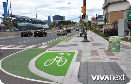
Waiting in the left turn lane with vehicles to cross multiple lanes of traffic and the rapidway may not feel safe on a bike, so green-painted ‘bike boxes’ are installed at corners of intersections. Here’s how they work:
Cyclists turning left at a rapidway intersection proceed straight through the intersection in the bike lane to the far side, stopping in the bike box. A bike box is a protected waiting area reserved for cyclists, tucked into the corner of an intersection. Once the light changes, the cyclist crosses with other vehicles and pedestrians. The bike boxes are clearly marked with green paint like the bike lanes, so drivers and pedestrians will know they are for cyclists. For a demonstration, see the video rapidway intersections: safe journeys.
Where do cyclists go once the bike lanes end?
North of Major Mackenzie and 19th Avenue/Gamble Road, and south of Highway 7, cyclists on Yonge Street will travel curbside or on the paved shoulder. For more information on cycling in York Region, please go to york.ca/cycling.
YRT makes it easy for you to commute with your bike and take transit to get to your destination. Here is more information about integrating cycling into your transit trip.
Contacts
Who can I call if I have a question about the rapidway construction project in Richmond Hill?
Keeping the public informed and engaged with our rapidway projects is important to us. Our Community Liaisons work with property owners, tenants, local businesses and residents. For more information, please contact:
Sophia Bittar
Yonge Street - Levendale to 19th/Gamble
Email: sophia.bittar@york.ca
Cell: 905-806-0713
Who can I call if I have questions about YRT or Viva service?
YRT Information Line:
Local: 905 762 2100
Toll free: 1 866 MOVE YRT [668 3978]
Monday to Friday: 7am–7pm
Saturday, Sunday and Holidays*: 8:30am–4:30pm
*Closed on Christmas and New Year’s Day
Online: talk2yrt.ca and live chat