Categories
Urban Planning

building sustainable communities

YouTube video: Building Sustainable Communities

As our towns and cities grow, we need to prepare for the future. Long term planning means that everything we need is all in the right place ahead of time. That means all the major necessities: transportation, utilities, community services and more.

In York Region, we know our population is continuing to grow – by 64% by 2031. Employment is also expected to increase by a whopping 59%, and all this will mean more demands on our roads in general [50% more demand in the morning peak], and especially an increased need for fast, convenient transit.

That’s why rapid transit systems are part of the plans in York Region. Bus Rapid Transit systems are supplying current and future demand with Viva rapidways that offer time savings. On the Highway 7 rapidway in Richmond Hill and Markham, travel times are 42% faster than in mixed traffic.

These improvements to our infrastructure are appreciated. On Davis Drive in Newmarket – the newest rapidway to open – YRT/Viva ridership increased by 39% between February 2016 and February 2015. According to a 2015 survey, 80% of residents living near an opened rapidway believe the project added value to their community.

From Markham to Newmarket to Richmond Hill and Vaughan, it’s about maintaining vibrant, welcoming communities that are prepared for growth and sustainable for many years to come.


Categories
Urban Planning

when urbanism comes to a small city, the impact is big

when urbanism comes to a small city, the impact is big

When urban projects that bring complete streets happen in a big city, they have an impact. A recent big-city example is Simcoe Street in Toronto, which increased pedestrian space and added bike lanes. But to be honest, these projects don’t create the same splash as they do in small cities. In fact, they can get a bit lost in amongst the city as a whole.

When urbanism comes to small or even medium-sized cities, the effect can be huge – even transformative – creating  a new downtown. And the vivaNext and subway project in Vaughan is doing just that.

A recent article, called “New Urbanism’s impact on small-to-midsize cities”, from the American journal Public Square, lays out several remarkable examples of the effects of complete streets’ on smaller centres.

The article describes the positive impacts urban projects have had on a selection of small U.S. cities:

  • Positive impacts in Birmingham, Michigan. Since urbanism came to Birmingham the city now attracts more shoppers and visitors. In fact, in the wake of the urbanism projects, Birmingham has changed its motto to “a walkable community”.
  • Revitalized Albuquerque, New Mexico. Urban changes to land use in Albuquerque have created “a lively mix of entertainment, shopping, office and houses in place of cheap surface parking and underused buildings.”
  • Formerly forlorn Providence, Rhode Island. Before the urbanism project in Providence, the city had a deserted, empty yet heritage-rich downtown. Urbanism has brought the area back to life “with a vengeance”.

Closer to home, the Highway 7 East vivaNext project in Markham has transformed the street from being a highway with gravel shoulders, to being an attractive place to walk, cycle, drive and shop with convenient rapid transit Viva buses along the route. The project has helped set the stage for new development in Markham, such as York University’s new campus.

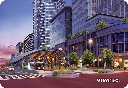
In Vaughan, people are starting to flock to the new urbanized area known as Vaughan Metropolitan Centre, which is seeing new urban development in Vaughan and includes design elements such as pedestrian-friendly boulevards, wider sidewalks, attractive landscaping, bicycle lanes, upcoming bus rapid transit and the Toronto-York Spadina Subway Extension [TYSSE]. New developments are coming to this new mobility hub, transforming the area.

Urbanism in York Region is part of the exciting movement for smaller cities to grow right, serving the Region’s communities for generations to come.

For more information on the vivaNext projects, be sure to sign up for email updates and follow us on Twitter. Questions or comments? Comment below or email us at contactus@vivanext.com.


Categories
Construction Rapidways Stations

form meets function where Viva meets the subway

form meets function where Viva meets the subway

There’s a lot happening near Highway 7 and Jane Street right now. With the subway extension, bus rapidway, bus terminal, and commercial and residential buildings being built, it’s difficult to distinguish one construction project from the other. In the past week though, one project has become more visible.

In the middle of Highway 7, between Jane Street and the Highway 400 ramps, a huge structure is being built. The VMC-Spadina Subway vivastation will play an important part of this transit-oriented area, connecting Viva customers to the subway below.

The station is supersized with longer and wider platforms, and the roof will cover the entire rapidway. Customers will be able to access the concourse below via elevator or stairs to access the new subway extension or walk a few minutes underground to catch YRT or Züm at a new bus terminal.

A few fun facts about the station:

  • Single canopy is 50m long x 22m wide – bigger than the other vivastations to accommodate more bus and passenger traffic.
  • Steel structure assembled as three roof sections [now installed]; eight ladder sections [the first just arrived]; and 70 smaller infill sections.
  • Uses a combination of aluminum, painted steel, ceramic frit and tinted glass panels – overall, the station will appear light grey with blue and white accents.
  • Up-lighting will illuminate the lattice pattern of steel supports and glass panels on the roof.
  • Real-time bus arrival screens in station waiting areas, and underground at concourse level.
  • Heated and unheated waiting areas on each platform.
  • 100% coverage by security cameras.
  • Windscreens to block the prevailing wind – potential showcases for public art.
  • Hidden rainwater gutters and downspouts to drain water under the roadway.

The steel structure can be seen in the middle of Highway 7, and this will take a couple of months to put into position, and another couple of months of welding. As you’ll soon see, this station will make the Vaughan Metropolitan Centre area look very different. And once it opens in 2018, will connect everyone to where they need to go.


Categories
Live-work-play Urban Planning

going where the action is

going where the action is

In York Region, there are over 120 bus routes travelled by Viva and YRT buses, and some are busier than others. Some of the busiest routes are on Yonge, Highway 7, Bathurst and Centre Streets, Bayview Avenue and Leslie Street. If you live or work in York Region, there’s a good chance that you travel one of these roads regularly, so it’s no surprise that other people want to go there too.

When building transit, planners have a few goals in mind: ensure most people have access to transportation; have transit where people want to get on and off; and be prepared for future growth and development.

Ensuring most people have access to transportation allows people to get where they want to go, even if they have a specific need or live in a less populated area. In York Region, Dial-a-Ride, community buses and seasonal services [like Canada’s Wonderland!] are examples of this. Community buses take people to places where there’s a special interest, like hospitals, plazas and schools.

The most popular transit routes go where people want to get on and off. People want to go where the action is, so routes are planned where shopping, services, jobs, and higher-density housing is already along the way. One example of this is the area around Bathurst and Centre Streets, where shops and amenities are walking distance to a transit terminal and multi-story condo buildings. Connections to other transit are a big draw too – so routes are planned near bus terminals, GO stations, and future subway stations.

In some cases, we’re preparing for future growth by building transit before development. Enterprise Boulevard in Markham is a planned downtown area near the Unionville GO Train Station that only seven years ago was mostly vacant fields. We opened the first segment of rapidway there in 2011, and since then condo buildings, a sports facility, shops, restaurants and entertainment have all been built, and hotels and a York University campus are on the way.

Whether development is already there or on the way, transit planning means making sure transit is easy to access, and goes where people want to go – an important element in building great communities.


Categories
Rapidways Urban Planning

building complete streets in York Region

building complete streets in York Region

When looking at the award winning rapidway on Highway 7 in Richmond Hill and Markham, or Davis Drive in Newmarket, you’ll notice some features that make them different from your average street.

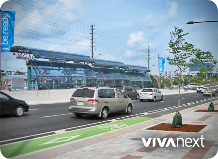
Wider sidewalks, more accessibility features, large attractive tree planters to provide a buffer between pedestrians and traffic, and bike lanes where possible, are all part of York Region’s urban design philosophy. It’s an approach that will shape the future of our communities and neighbourhoods, and it’s what Urban Planners call a ‘complete street’ – a street designed for everyone.

The complete street transformation is starting to unfold on Yonge Street in Richmond Hill and Newmarket this year. Utilities are being relocated to accommodate the dedicated bus rapid transit lanes in the centre of the road. In time, the same thoughtful and elegant elements will take shape on one of the region’s most important roads for transportation, commerce and entertainment – the perfect place to stop, shop and dine – Yonge Street!

The complete street approach ensures that planners and engineers design and manage public infrastructure that takes in account users of all ages, abilities, and modes of travel.

One of the underpinnings of the complete street approach is to treat roads as destinations. With careful planning, roads can be public spaces with lush greenery and design features that engage people. Streets can be places to go instead of just surfaces to drive on. They should connect to businesses and places where people live, and also to trails, parks and other gathering places in order to help build a sense of community.

Another key consideration is accessibility, because whether you get around in a stroller, wheelchair, on transit, walking, cycling or driving, everyone needs safe and convenient options.

To learn more about complete streets and how they are being implemented across Canada and around the world, visit completestreetsforcanada.ca, or smartgrowthamerica.org.


Categories
Going Green Urban Planning

farms need cities

farms need cities

Most people would agree that outside the city limits, there should be rural, green space. It’s important for agriculture, for wildlife, and for us to experience our natural landscape.

The Oak Ridges Moraine Act [2001] and the Greenbelt Act [2005] together protect 69% of York Region’s land. Considering York Region’s fast growth, the remaining 31% needs to be carefully planned, with higher density in the cities.

Farmland has changed in Ontario over the last several decades, with fewer, larger farms and more technology used for efficient production. Wildlife has changed too, with York Regional Forests in place and more awareness of our impact on nature. But one thing that hasn’t, and likely won’t, change is that wildlife and farms need cities to grow in place, without expanding into the countryside.

This is where new urbanism and transit-oriented development come in. They’re about planning the best ways for a city to grow, and ensuring there’s a variety of housing and employment, and transportation options like bus rapid transit and subway. Building where we already have development makes a lot of sense. It keeps urban, urban and protects rural from becoming suburban. It also creates a focused city centre that attracts people to do business or shop, all of which is supported by great transit to get around.

Using the land we already have in York Region’s cities and towns is smart and it’s sustainable. If we stick to this plan we’ll be watching population grow in our vibrant cities, and trees and crops thrive in the country.


Categories
General Studies Urban Planning

how transit and city planning work together

how transit and city planning work together

An exciting new urban planning report — Make Way for Mid-Rise: How to build more homes in walkable, transit-connected neighbourhoods proposes actions that would help increase density along transit lines in the Greater Toronto Area. The report was released by the Pembina Institute and the Ontario Home Builders’ Association on Monday, May 4.

The nugget of this report is that the range of affordable housing choices for families would increase by building mid-rise, mixed-use buildings along transit lines. The report argues that mid-rise development supports “healthy lifestyles and local economies, since it can help increase walkability and put more people close to transit, while also supporting local business.”

So, should our communities “make way for mid-rise”? If we want our cities to have a better chance of developing the type of population density that supports a healthy neighbourhood with street life, walkability, and good transit, then, yes!

As the populations of York Region and the Greater Toronto and Hamilton Area increase, it’s the job of government, urban planners, and developers to ensure that the community infrastructure is properly accommodated, and resources like farmland and clean water are protected.

The Make Way for Mid-Rise report presents five ways to support increased density:

  1. Require minimum densities along rapid transit lines
  2. Eliminate minimum parking requirements
  3. Pre-approve mid-rise development along avenues and transit corridors
  4. Require retail planning before mid-rise is built
  5. Make parkland dedication rules more equitable

When transit planning and urban planning work together, the result can be what vivaNext is all about: great cities and great transit, hand in hand.

Take a few moments to check out the report, Make Way for Mid-Rise, and read more about the proposals in the Toronto Star.


Categories
Stations Urban Planning

why stop here?

why stop here?

Some of the most successful investors will tell you that thinking long-term is the best way to make decisions. That’s also the route transit planners take, and a long-term increase in passengers is the goal for the investment.

Rapid transit routes are also planned with potential growth opportunities in mind. By looking at municipal zoning and ‘big picture’ plans, higher levels of government and planners can see where higher-density residential and commercial development will be located in the future. They look at the area around each proposed station to see if it seems likely to redevelop into higher-density residential and commercial destinations. Key pointers tend to be municipal zoning that allows for multi-story buildings, large lot sizes, and older buildings that are more likely to need rebuilding or refurbishing. Stations are especially considered at junctions where current or future transit lines intersect. The area may already have urban amenities and high population, or in some areas, empty land is zoned for a planned high-density community. It’s not necessarily about what’s there now, it’s about what could be there.

By studying the facts, transit planners can be confident about where transit stops should be placed, and know that as the community evolves in future years, new developments will naturally make it more compact, transit-oriented and pedestrian-friendly.

In York Region, the location of rapid transit routes is studied carefully to ensure that as our population continues to grow in the long-term, we’ve invested in a great transit system to support it. The Viva routes were planned with that in mind and now with ridership increasing steadily, rapid transit is moving to one dedicated lane in the centre of the road. With this comes a balanced community that provides vibrant urban centres, faster travel choices, and routes that have more connection points and better serve customers


Categories
Urban Planning

building great cities

Building Great Cities

York Region’s Centres and Corridors strategy is how our Region is making sure there will be room for our growing population to live, work and play, while also protecting our sensitive lands and green zones. As our Region grows, new homes, workplaces, retail and recreational facilities are being established all along the corridors, and clustered in higher density centres in Vaughan, Richmond Hill, Markham and Newmarket.  And to make it easier for people to get where they want to go, without always needing to get in their car, rapid transit corridors featuring Viva’s comfortable Bus Rapid Transit service will link those centres.

Centres and Corridors has been a key component of Regional Council’s strategic priorities, and the amount of development actively underway in all the centres shows that great progress is already being made. But what are the steps required behind the scenes, to create the kinds of communities that are taking shape in the centres?

The first step, and one that was approved long ago, is that Regional Council provided strategic direction confirming the Centres and Corridors plan as the foundation for the Region’s Official Plan.  The Provincial Growth Plan for the Greater Golden Horseshoe reinforces the principles of increased intensification and city-building, and specifically identifies the four centres as “urban growth centres.”

Included in the Provincial Growth Plan are targets for the number of people and jobs to be supported per hectare. The Region’s Official Plan includes these targets, and also establishes policies to encourage transit, pedestrian-friendly street designs, and mixed-use development.

Building on the Region’s policies, each municipality then has to review their own official plan to make sure it conforms and supports the Region’s plan. Municipalities then develop secondary plans, which set out specific land use rules and targets for defined areas including the centres.  Secondary plans shape future development, providing guidance on minimum densities, building heights, streetscaping and other strategies to encourage welcoming, pedestrian-friendly development.

Once the general rules for land use have been developed, municipalities and the Region then actively work to attract new employers and development investments.  Economic Development experts work with their Planning Department colleagues and with potential investors, to create new or expanded work opportunities.  A key driver for many of the new employment opportunities that have already been announced in York Region is the proximity to rapid transit, and the availability of a strong, educated workforce.

And the last component of our multi-pronged approach is to ensure that new housing options are available all along the corridors and in the centres.  We know that people want to live relatively near to where they work, with a short commute being highly valued.  The new housing developments that are springing up near our vivaNext routes are already providing very attractive options for people wanting an urban home, with great access to transit and work.

City-building isn’t a short-term process, but with all these components working together, bit by bit our centres and corridors are being transformed into exciting, urban places, while protecting and respecting existing developments and our natural environment.  For everyone, that means more options, more choices, and linking it all together, more Viva.


Categories
Construction Rapidways

bringing the vivaNext long-term plan for the future to life

video - Highway 7 East: summer update 2014

With crews working on the finishing touches on the eastern half of the Highway 7 rapidway, we’re getting closer to the completion of this rapid transit corridor. As much as we’re looking forward to celebrating this milestone, it’s only one [very exciting] step in a long path that started years ago.

There’s a lot of media coverage these days, of transit needs all across the Greater Toronto and Hamilton Area [GTHA], and we’re proud that York Region is actively working to bring rapid transit to our region. In 2002, the Region produced the York Region Transportation Master Plan and the follow-up Rapid Transit Plan, committing the Region to a blueprint of multiple transportation initiatives to be built over the next 30 years.

With approval to the Rapid Transit Plan, we got to work and in 2005 the Viva team launched “QuickStart,” the first phase of Viva service. Viva offered enhanced features that made transit more comfortable and convenient, and put the customer first. With ridership levels increasing steadily, Viva changed the way people in York Region thought of transit and there was appreciation for the higher level of services with enhanced features and frequencies.

But while our new Viva service was a major success and an important first step in encouraging people to try transit, designing the vivaNext rapid transit system was the Region’s long-term vision. Ontario municipalities are mandated to plan sustainable, more intensive land-use as part of the provincial government policy, and rapid transit is a key component in achieving that goal. Anticipating this, the Transportation Master Plan directed that future growth in York Region would be concentrated in new downtowns in Markham, Newmarket, Richmond Hill and Vaughan. By building more intensively in these areas, there would be less pressure for growth in existing neighbourhoods.

These urban centres would be connected by transportation “corridors,” making it easier for people to get around the region and providing transportation options, such as regular transit service. The vivaNext rapidways are being built along the corridors, providing these connections across York Region and into the rest of the GTHA.

Much of the new development being built around vivastations is compact and mixed-use, providing housing, employment, retail, dining, services and recreation, all within walking distance of transit. Developments include more welcoming public spaces, attractive landscaping, and other amenities that contribute to the centres becoming more dynamic destinations.

The plan is well and truly underway, and rapidways are being built on Highway 7 in both the east and west, as well as in Newmarket. The Toronto-York Spadina Subway Extension is under construction, and the designs for rapidways on Yonge Street are being finalized. Great new developments are popping up all over the new urban centres across the Region.

So when the next segment of rapidway on Highway 7 East starts service this summer, we can all celebrate the implementation of the first phase of our transportation and growth management blueprint, not to mention the end of construction! Check out the new video highlighting the Highway 7 East segment.