Categories
Construction economic & financial economic benefits Going Green Live-work-play Rapidways suburban to urban transformation Transit Uncategorized Urban Planning

at Bathurst & Centre, the goal is more than just a rapidway

With the summer months now behind us, the rapidway project in the Bathurst & Centre community continues to make great progress, with all five vivastations under construction, utility upgrades complete, sidewalks and boulevards well underway, and base and final paving making great headway.

With the rapidway scheduled to open for service by the end of 2019, it’s a good time to remember what the goal of the project is: to design and deliver rapid transit projects that attract, move and connect people to York Region’s urban centres.

This goal translates into what’s called a “triple-bottom-line” contribution to our community – specifically social, environmental and economic benefits. They include:

  • Urban transformation. Emerging along the length of our rapid transit network, traditional suburban development is transforming into more compact urban neighbourhoods that include retail, entertainment, dining, places of worship, residential and offices. As the population of York Region grows and increases in density, we are building transit to service this population.
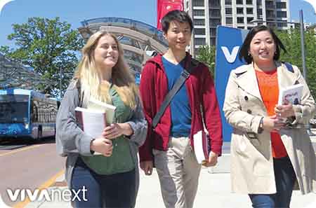
  • Connections. The new sections of rapidway will consist of 5 new vivastations along Bathurst and Centre, connecting people from Thornhill to Concord, Woodbridge and Vaughan Metropolitan Centre and the subway to Toronto. It will also connect people to the rest of York Region via the Richmond Hill Centre Terminal at Yonge Street and Highway 7, and the future Yonge Subway Extension.
  • New businesses. As new developments provide new housing choices, the area attracts new employers – businesses that want to be located near transit in order to draw on a well-educated workforce.
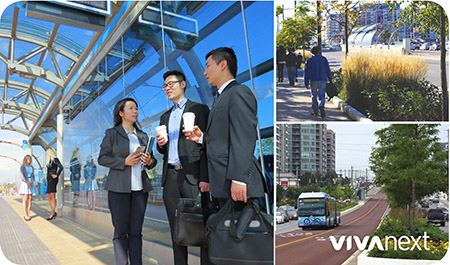
  • Less driving, more moving. As York Region welcomes this new transit and cycling infrastructure and an increasing population, the result is more transit riders and reduced dependency on cars. Less time spent behind the wheel of a car can have great benefits to long-term health because people walk, run or cycle more – for exercise and to get from place to place.
  • Cleaner air. Every busload has the potential to replace 70 cars, and fewer cars on the road means reduced carbon emissions.
  • Building transit where the people are. The most popular transit routes go where people want to get on and off. People want to get to where the action is, so routes are planned where shopping, services, jobs, and higher-density housing is already along the way. The Bathurst and Centre neighbourhood is a perfect example of this as the community has a multitude of shops and amenities, multi-story condo buildings and residential streets – and busy Viva routes already service the community.

In York Region, a number of urban centres like Bathurst & Centre are evolving into mixed-use communities. At vivaNext, we’re supporting that change by building a fast, convenient rapid transit system. As part of the Centres and Corridors initiative, York Region has a vision and best practices for new mixed-use development to make sure that it gets built in areas which are supported by higher levels of transit.

For information about ongoing vivaNext projects, be sure to subscribe to email updates, and follow us on Twitter. You can also follow us on Instagram, YouTube and Facebook. Questions or comments? Comment below or email us at contactus@vivanext.com.

Categories
Innovation Urban Planning

municipalities of the future

municipalities of the future

Earlier this month we were excited to be part of the Municipalities of the Future Symposium, hosted in Vaughan by York University. President of York Region Rapid Transit Corp. [YRRTC], Mary-Frances Turner, gave the keynote presentation, talking about trends and future innovation.

megatrends

Mary-Frances’ presentation highlighted a video by HP that talked about keeping up in this ever-changing world, by planning around these “megatrends”:

  • Rapid urbanization – larger cities, more cities
  • Changing demographics – aging population and lower birthrate, shrinking workforce
  • Hyper global and hyper local – everything connected to the internet, but customization is key
  • Accelerated innovation – market for new ideas and innovative business models, businesses reinventing themselves

future innovation >> smart growth

Looking at the state of the GTA, and global examples of transportation innovation, Mary-Frances talked about the need for “smart growth” in our cities and towns. In York Region, we expect to see a 49% rise in population and a 50% increase in jobs by 2041, but traffic congestion has been the number one concern of residents for the past 13 years.

What is smart growth? It’s compact, higher density development, maximizing the amount of places to live, work and be entertained, within walking distance of transit – where mobility and connections are seamless, regardless of municipal boundaries.

Smart growth includes better access to transportation – including transit, and future innovative technology. In the GTA, we’ve already created better access to health services, education and businesses with transit:

  • Dedicated bus lanes – rapidways – at the doorstep of Southlake Hospital in Newmarket and Markham-Stouffville Hospital in Markham.
  • Direct connection to subway in Vaughan, which stops at York University.
  • Viva rapidway stations near Seneca College’s Markham Campus and the future York University campus in Markham Centre.
  • Easy access for Viva riders and pedestrians to businesses along Davis Drive in Newmarket, and Highway 7 East and West in Markham and Vaughan.

There’s much left to do, including more transit, and more transportation options. Whether it’s bus rapidways, subway extensions, car sharing or drone taxis, there is a world of options out there. At YRRTC, we’re committed to being ready, by working with others to ensure guiding policies result in a successful future, by remaining open to changes in technology and the demands of new demographics, and by thinking outside the norm.

Categories
Announcements Commissioning Community Events Construction Facilities and terminals General Rapidways Stations Subways Urban Planning

Transit gets epic in Vaughan this Sunday

Get ready for the game-changer. Transit is about to get epic at the Vaughan Metropolitan Centre [VMC], and you’re invited. On Sunday, December 17, this public launch event is set to change the face of transit forever in York Region.

The public opening of the TTC Line 1 Subway Extension will make history, as the first subway ever in York Region brings transit customers up to Vaughan Metropolitan Centre.

Today was another great day for integrated transit connections in the York Region and the GTHA – as we celebrated the official opening of the newest bus rapid transit [BRT] rapidway segment and Vaughan Metropolitan Centre [VMC] Station on Highway 7 West. This new vivastation will be fully connected to the new VMC subway station.

Bus rapid transit meets subway for the first time!

you’ll be moved!

The new rapidway section runs west of Jane Street to Edgeley Boulevard, with dedicated centre lanes that will whisk riders to the VMC with faster and more consistent travel times. Including the previously completed section, the rapidway will run the full 3.6 kilometres from Bowes Road to Edgeley, the bus-only lanes clearly marked for drivers with red asphalt.

Coming in 2018, SmartCentres Place Bus Terminal will complete the transit powerhouse at VMC, as YRT buses begin providing services from this stunning new bus terminal.

an extraordinary station

Along with the rapidway comes an extraordinary vivastation for a new downtown destination – the Vaughan Metropolitan Centre rapidway station. The design supersized our traditional vivastation arched glass canopies, inspired by historic and modern European transportation architecture. The open, airy, domed glass canopy shelters the road and station.

the future is now

It’s only 43 minutes via subway to downtown from the VMC, but there’s no need to go anywhere. If you’re at Vaughan Metropolitan Centre, you’ve already arrived!

Welcome to the brilliant future of transit-oriented development, right here, right now in York Region. The VMC shows what it’s all been about: rapid transit connections that fuel livable, walkable, desirable communities, spur jobs and economic growth, creating places where we all want to live, work and play.


Categories
Announcements economic & financial General Live-work-play Safety Studies Urban Planning

home, safe, home in York Region

If you want to live in a safe place, come to York Region. York Region is one of the safer places in Canada to call home, according to Maclean’s magazine list of Canada’s most dangerous places to live.

low crime rates

The Region is well down the list at #201, making it the 30th safest area to live in.

The rankings come from a crime severity index, calculated by the type and frequency of crime: violence, drugs, theft/property and youth crime. York Region falls below the national average on every front, often far below.

See the rankings

strong communities by design

Low crime is just one of the many reasons our region is a great place to live, along with the Region’s thriving economy, impressive job growth and strong sense of community. In the future, we hope our Region will also be known for the strength of its rapid transit network.

At vivaNext, we’re fortifying the future of our communities with rapidways. Having a transit network in place is the ticket for transit-oriented development — smart growth designed with the new urbanism in mind. The vision is one of compact, walkable communities served by transit, where people want to live.

We know we need to be ready for our Region’s future population – we’re expected to reach 1.79 million residents by 2041, up from today’s 1.2 million. But we also want to preserve the essence of our communities that made them desirable in the first place.

streets for everyone

VivaNext rapidways come with streets for everyone: pedestrians, cyclists, drivers and transit riders. Attractive streetscapes and landscaping enhance the allure. The rapid transit projects foster mixed-use land development, increasing population density while reducing urban sprawl. These are the kind of communities that go the distance, designed to be strong, caring and safe for the long-haul.


Categories
Announcements Awards Commissioning Facilities and terminals General Press Rapidways Stations Subways Urban Planning

be ready… 30 days to subway

The countdown is on, and we can hardly wait! The first subway in York Region will arrive in just 30 days. The TTC Line 1 subway extension is a game-changer for transit in Vaughan Metropolitan Centre [VMC], York Region, and beyond.

Changes of this magnitude are fueled by the power of collaboration and funding partnerships. Today, vivaNext participated in a media event to kick off the countdown in earnest, along with the Government of Canada, the Province of Ontario, the City of Toronto and the TTC.

Read the news release

mega-connections at VMC

The TTC Line 1 extension isn’t the only connection coming your way. Everything’s changing, and that makes for better, faster transit service.

  • The Highway 7 West rapidway between Edgeley Boulevard and Jane Street, including Vaughan Metropolitan Centre Station in the centre of Highway 7, will open for service.
  • SmartCentres Place Bus Terminal will begin hosting YRT/Viva soon after.

Imagine, hopping on Line 1 at VMC Station and arriving downtown in just 45 minutes. Or from the subway, connecting directly to our Highway 7 West rapidway, or walking two minutes to the SmartCentres Place Bus Terminal, where YRT/Viva routes branch out across York Region. Soon you won’t have to imagine!

Today’s event was a warm-up for the big celebration on December 17, and you’re invited to share the celebration. Check vivaNext.com/VMCopening for links to detailed information.

award-winning design

In other news, our rapidway in Vaughan is already getting noticed, for the quality of the design and also for the collaboration behind the scenes that makes it all come together.

Earlier this week, we were honoured to receive an Award of Merit from the Vaughan Urban Design Awards for the first phase of our Highway 7 West rapidway. The awards celebrate excellence in architecture, urban design, landscape architecture and environmental stewardship.

The rapidway, running from Jane Street to Bowes Road, was unanimously praised by the jury as “A great example of collaboration and investment between multiple levels of government to demonstrate significance on a city-wide scale.”

The jury also called the rapidway “a catalyst to knit communities together”, noting that the project “presents public transit as a ‘cool and hip’ mode of transportation” and “makes the everyday experience of transit a beautiful one.”

We hope you agree. Riding transit can be a beautiful experience.

Categories
Commissioning Construction Going Green Innovation Safety Stations Technical Urban Planning

rain, rain, go away

Our new rapidway station at Vaughan Metropolitan Centre is ready for the rain, innately designed to handle a downpour and keep those pesky puddles off the road.

Large structures like the new bus rapid transit station shed a lot of rain during storms. With the size of the station’s roof, the volume of water collecting from even light rain storms would be enough to create some pretty major puddles.

Water management has been a key design consideration for the station since day 1. Letting runoff drain freely onto the roads isn’t an option since the station is right in the middle of Highway 7. Here’s the rundown on how we’re managing runoff.

Water management strategy includes features built into the station’s design, and the design of the road and storm water management systems around the station.

Gutters run along the curved station roof between the skylight and the roof panels, designed to collect and funnel water to the ends of the station. At that point, brow gutters – shaped like eye-brows – will drain the water into downspouts on the sides of the station, which then drain safely into underground catchbasins connected to the storm water management system.

But that’s not all! Water from the middle portion of the roof, below the roof gutters, will drain off the roof onto the road. Generally at our vivastations, the road design ensures water doesn’t become puddles.  A very gradual slope away from the station to the curb lane directs the water into a series of curbside storm sewers and catch basins.

However, the VMC station is so much larger than the other stations, there’s simply too much water to direct across the road. Instead, we drain the water closer to the station.

We’ve built up the road surface so that its highest point is 1.2 metres away from the station.  Water draining off the station will be naturally directed back towards the station, running along the curb into a series of catchbasins and into the storm sewers.

We know that rain gutters and catchbasins aren’t the most glamourous features of the new station, but on a rainy day, we’ll all be glad they’re there.

Categories
Live-work-play Urban Planning

live, work, play…and study in Markham!

live, work, play…and study in Markham!

The City of Markham is growing quickly, and for some time now has been considered a major employment hub, especially in the tech sectors. According to Markham’s website, of the 10,400 companies in Markham, there are more than 400 Canadian head offices located there. This includes IBM, GE Digital Energy, Honeywell, Johnson & Johnson, Honda – you get the picture. As an article in Computer Dealer News points out, York Region and especially Markham, has the highest concentration of Information, Communication and Technology [ICT] firms in Canada. Given its role as a key employment centre, it’s no surprise Markham has a large population of residents – it’s the GTA’s fourth-largest city, and York Region’s biggest municipality.

GO, all day

So naturally, there are people travelling to and from work in Markham, and they’re going to need more options for getting there. GO trains are a popular choice, so it stands to reason that GO Transit’s Stouffville Line travelling through Markham should be expanded. Last week, MTO announced increased, all-day GO train service on weekdays, starting later this month. 17 new trains trips per weekday will double the number of weekly trips on the Stouffville line from 85 to 170. GO passengers connect to Viva and the Highway 7 rapidway at Unionville Station, and YRT at Centennial, Markham and Mount Joy Stations.

York U

Last Friday, the Province of Ontario announced $127 million in funding to help build the new York University campus in Markham. The campus has been in the plans since 2015, when the Province agreed the new campus should be located in Markham. Set to open in 2021, it will host 4,400 students – both graduate and undergraduate – and partner with Seneca Collage to offer some programs. Seneca’s Markham campus is already nearby, a stone’s throw from Allstate Station on the Highway 7 rapidway.

Markham is growing – with plans and transit in place to support that growth. Having more travel and education choices is a wonderful thing no matter where you are, and we’re excited to see it happening here in Markham!

Categories
Accessibility Urban Planning

helping seniors stay connected with transit


When we consider the need for transit, we often think about the students and workers on their daily rush-hour commute. But there’s a growing population that will be making more use of transit in the next 15+ years. By 2031, one in five people in York Region will be 65 or older.

Keeping seniors connected means having accessible, convenient transit nearby. In fact, York Region’s Seniors Strategy: Thinking Ahead [2016], points out transportation as one of the key priorities for seniors. Two of the Region’s four identified roles – enabling aging in place by supporting age-friendly, complete communities; and helping seniors stay safe and connected – are closely tied to the availability of transportation options.

aging in place and staying connected

The term, “aging in place”, essentially means helping to make it possible for seniors to live where they choose, and to get the supports they need for as long as possible.

Keeping seniors connected means having accessible, convenient transit nearby. Our senior population has different needs, depending on many factors including age. Younger seniors may still be working and very active, compared to the older senior population who may have more mobility issues and medical needs, and a less of a social network. Some may choose to live without a car, making other options such as transit or walking even more important.

accessibility and walkability

To help seniors age in place, complete communities need to be walkable, and include a mixture of different housing and amenities. The new vivaNext streetscapes and rapidway infrastructure we’re building in Markham, Richmond Hill, Newmarket and Vaughan are accessible and walkable, and set the stage for planned growth, including places to live, work, access services and medical care, shop and dine.

senior citizens rule!

Life continues to be active and fulfilling for seniors. In fact, the senior citizen population of York Region contributes significantly to their communities through volunteer work. And the history books are full of examples of seniors doing amazing things – like Ed Whitlock of Milton, Ontario, who at 69 became the oldest person to run a standard marathon in under three hours. At 77, John Glenn became the oldest person to go into space.

Whether it’s getting to the grocery store, going to the community centre to volunteer, attending medical appointments or just visiting with friends and family, we’re building the connections seniors will need.

Categories
economic & financial Urban Planning

change that works

change that works

Cities around the world are searching for safe, sustainable ways to provide mobility to residents across towns and cities. VivaNext, a leader in rapid transit, has risen to the challenge. We pride ourselves on designing a great transportation system that has social significance and measurable benefits.

VivaNext is proud to support the triple bottom line. This business principle holds that business activities should result in financial, social and environmental benefits. The benefits of rapidways are easy to see. For example, the dedicated bus lanes not only allow for fast, convenient service across the region, but they also help facilitate a safer road for drivers, pedestrians and cyclists alike. In addition, emergency service vehicles are able to access the rapidways and cross the median at designated intervals, which improves their response time and bypasses congestion.

What may not be immediately visible, however, are some of the positive economic and environmental impacts rapidways create for communities.

economic development & impact

  • Well thought-out and well-designed transit attracts sustainable, mixed-use development, including new businesses, jobs and a variety of housing options
  • Easy access to transit creates a more desirable mixed-use neighbourhood, and allows for money to be reinvested into the community (through businesses or reinvesting in local infrastructure)
  • Based on other rapid transit projects across North America, property values increase for land within walking distance to transit stations
  • As the Region’s urban transit corridors evolve and attract new retail and restaurants, other new employers wanting to be near transit will follow, continuing to support future economic and social growth

environmental responsibility

  • Every busload replaces approximately 70 vehicles on the road, which means a reduced carbon footprint
  • Rapid transit systems create a safer, more accessible and walkable city

With so many positive benefits of rapid transit, it’s no wonder York Region is a leader in transforming our communities by providing safe, convenient rapid transit. Join us and be moved.

Categories
Accessibility Safety Technical Urban Planning

making corners work for everyone

making corners work for everyone

In civil engineering-speak, curb radius refers to the curve of the curb as it goes around a corner; sometimes it’s a wide gentle bend, and sometimes it’s a tight right angle. So here’s a question: when’s the last time you waited at an intersection for the light to change and actually even noticed the curb radius?  If you’re like pretty much everyone else, probably never.

And yet, believe it or not, the curb radius is one of the most important components of streetscaping, and has a profound influence on how drivers and pedestrians use a street.

As you already know, streetscaping refers to all the elements making up the public spaces along our streets. Because a key vivaNext goal is to make everyone feel welcome on our streets, whether they’re walking, biking, waiting to hop on Viva, or driving, we pay a lot of attention to streetscaping considerations. This includes the curb radii for every single intersection and entrance along our rapidways.

The curb radius describes the shape of a corner, such as when two perpendicular streets come together at an intersection, for example. The curb radius is expressed as a number, taken from the radius of the curve connecting the curbs of the two streets. On a wide suburban corner, the curb radius might be as high as 35, whereas on an urban street corner, it might only be 2.

Most urban settings, including along our vivaNext rapidways, aim for a smaller curb radius wherever possible.  That’s because the smaller the curb radius, the shorter the distance a pedestrian has to walk to get to the other side of the road. A smaller curb radius has other impacts too. It results in more space at the corner, including more space for accessible ramps. It makes it easier to line up crosswalks with connecting sidewalks.  It improves the sightlines for pedestrians and makes pedestrians more visible to drivers. And it slows down turning movements for vehicles going around corners, which is safer for pedestrians.

Of course, curb radius design also considers the needs of drivers, including traffic volume, vehicle size, and their desired speed going around corners. It also has to take into account bike lanes, on-street parking, bus stops, emergency vehicles, and other design requirements.  Whether or not the road is part of a truck route may affect the curb radius, because trucks need a larger turning radius to be able to navigate turns while staying within their lane.

Our final curb radius design isn’t up to us alone, of course.  Our designs reflect standards and requirements set by York Region and the municipalities as part of their broader planning for their regional and local road networks. Those requirements in turn reflect the design standards from a variety of authorities including guidelines from the Transportation Association of Canada and the Ontario Ministry of Transportation.

There’s a lot involved in the design of a simple concrete curb than you probably would have guessed. But the final result is for a more welcoming, safe and accessible streetscape for all users.