Categories
History

crossing a river and marking history on Davis Drive

crossing a river and marking history on Davis Drive

Earlier this week we helped the Town of Newmarket celebrate the history of transportation in Newmarket, at the Keith Bridge on Davis Drive.

The Keith Bridge crosses the Holland River, which was an important centre of the original village in the early 1800s, with a grist mill, tannery, and the earliest settlers nearby. The trade routes from the old market of “York” in the south [now City of Toronto] to this “new market” in the north were important, and led traders and settlers to destinations farther north. In the early 1800s Yonge Street was built, following a branch of the Toronto Carrying-Place Trail used by natives and traders. About 50 years later the first railroad came to Newmarket, following the Holland River near Newmarket’s current Main Street.

Davis Drive played an important role in connecting Yonge Street to the railway and market near Main Street, and over time developed into a place of homes and businesses. In recent years, the Tom Taylor Trail has connected Newmarket with a beautiful place to bike and walk, including crossing under the Keith Bridge.

When the vivaNext project built the Keith Bridge as part of the Davis Drive rapidway, it was transformed from a utilitarian bridge going unnoticed by passersby, into an attractive landmark. It’s not just about appearance though. The Keith Bridge is wider, allowing for the new rapidway lanes and wider sidewalks for pedestrians. Construction also included improved utility lines under the bridge and of course the infrastructure itself, built to last for generations.

We hope that as everyone crosses, they’re reminded of the history of the river, the road and Newmarket. If you’re walking, be sure to stop and take a close look at the beautiful series of historical plaques along the bridge. As we celebrate Canada Day, it is wonderful to preserve a piece of history.

Categories
Live-work-play Urban Planning

live, work, play…and study in Markham!

live, work, play…and study in Markham!

The City of Markham is growing quickly, and for some time now has been considered a major employment hub, especially in the tech sectors. According to Markham’s website, of the 10,400 companies in Markham, there are more than 400 Canadian head offices located there. This includes IBM, GE Digital Energy, Honeywell, Johnson & Johnson, Honda – you get the picture. As an article in Computer Dealer News points out, York Region and especially Markham, has the highest concentration of Information, Communication and Technology [ICT] firms in Canada. Given its role as a key employment centre, it’s no surprise Markham has a large population of residents – it’s the GTA’s fourth-largest city, and York Region’s biggest municipality.

GO, all day

So naturally, there are people travelling to and from work in Markham, and they’re going to need more options for getting there. GO trains are a popular choice, so it stands to reason that GO Transit’s Stouffville Line travelling through Markham should be expanded. Last week, MTO announced increased, all-day GO train service on weekdays, starting later this month. 17 new trains trips per weekday will double the number of weekly trips on the Stouffville line from 85 to 170. GO passengers connect to Viva and the Highway 7 rapidway at Unionville Station, and YRT at Centennial, Markham and Mount Joy Stations.

York U

Last Friday, the Province of Ontario announced $127 million in funding to help build the new York University campus in Markham. The campus has been in the plans since 2015, when the Province agreed the new campus should be located in Markham. Set to open in 2021, it will host 4,400 students – both graduate and undergraduate – and partner with Seneca Collage to offer some programs. Seneca’s Markham campus is already nearby, a stone’s throw from Allstate Station on the Highway 7 rapidway.

Markham is growing – with plans and transit in place to support that growth. Having more travel and education choices is a wonderful thing no matter where you are, and we’re excited to see it happening here in Markham!

Categories
Construction Utilities

the utility bonus

click here to see our YouTube video about utilities!

If you’re a regular reader of this blog, you’ve probably noticed how often we post a story on some aspect of utility infrastructure. That’s because, as much as our main focus is transit, relocating and upgrading utilities is a very significant  piece of our construction project just on its own, in terms of effort, time and money.

Most of our posts are about the complexities and challenges of utility relocation. But the most important story is about the bonus: at the same time as we’re building new transit, York Region residents and businesses are going to be getting new telecommunications, water, sewage, drainage, power and gas lines to power them into the future.

Unlike a single construction project with one overall manager, the utility project demands that many players work together collaboratively. Working within multiple agreements and relationships, our projects [funded by Metrolinx], the Regional and local municipalities, and the utility companies all work together to coordinate the utility construction.

Whereas York Region Rapid Transit Corporation leads the design decisions for the transit project, it’s the utility companies – including private companies and municipal utility companies – who determine what they need to meet the needs of their customers. Starting with our project’s alignment and overall design, it’s up to the utility companies to decide what infrastructure they’ll need as the population grows, and where it needs to go. For this, they need to take into account future development as well as current needs.

Because there’s not much room down there, and there’s a logical order to what goes in first, the utilities need to work out their plans in ways that work for everyone. In some cases they can jointly locate their services, but more often they need their own space within a separate trench or on an overhead line. Finally, they are responsible for carrying out their own construction, with only one crew able to work in a given area at a time.

Because we’re all equal players in this, coordinating activities requires us to work together, including our project team, the designers and construction experts working for the utility companies, and the various levels of government.

With every vivaNext corridor that gets completed, the end result is increased telecommunications capacity, upgraded water and sewage, better drainage, and new service connections to individual houses and businesses. That’s a future bonus that’s definitely worth the effort and a benefit for everyone.


Categories
Rapidways Uncategorized

what exactly is a ‘partial rapidway’ ?

what exactly is a ‘partial rapidway’ ?

Where there are dedicated rapidways in York Region, there are also transition areas to get buses in and out of mixed traffic – and something called “partial rapidways”. Here are some simple explanations of what will be happening with transit in these areas.

full dedicated rapidway

The typical rapidways are dedicated lanes in the centre of the road for buses serving specific Viva routes. Vivastations are located roughly every kilometre or so, with customers being able to access the stations via signals at intersection crosswalks. Rapidways will allow Viva vehicles to zip past regular traffic.

transition lanes

Transition lanes take the buses into and out of the centre-lane rapidway. A good example of this is on Davis Drive west of Yonge Street.

partial rapidway

For the purposes of the vivaNext projects, partial rapidway typically means dedicated bus lanes in one direction of a roadway only. For example, in the Bathurst & Centre area, there will be dedicated rapidway for the most part on Bathurst and Centre Streets, and partial rapidway in three locations:

  • On Centre Street between Highway 7 and Dufferin Street, there will be regular centre-lane rapidway going westbound, and partial rapidway eastbound (full rapidway starts part-way).
  • The rapidway on Bathurst Street over Highway 407 and Highway 7 will be one direction southbound. The northbound rapidway will end just north of Flamingo Road.
  • The rapidway on Highway 7 between Bathurst Street and Yonge Street will be one direction eastbound. The westbound Viva route will run in mixed traffic.

transit in mixed traffic

While a partial rapidway is still in the centre lane, when Viva bus routes run in regular mixed traffic, there are no designated lanes, meaning that buses will travel in lanes that are also used by other vehicles. This usually occurs along roadway areas that are more highway-like without a lot of residential or commercial development, and therefore not a lot of customers.

For example, on Highway 7 roughly between Bayview Avenue and Yonge Street, Viva buses exit the rapidway and rejoin regular mixed traffic. Also, in the short section along Highway 7 between the GO Barrie bridge underpass and Centre St., there is no road widening or improvements as the underpass is not being widened. Therefore, in this stretch, transit will be in mixed traffic.

curbside rapidway

The vivastation at Bayview Avenue is curb-side with two levels, to allow customers to transfer between east-west transit service on Highway 7 and north-south service above on Bayview Avenue.

Designing rapidways is complicated, but it takes into account the local area geography and the ridership levels, today and in the future. This ensures that vivaNext is building dedicated lanes in areas that will see the highest levels of improved travel times.

Any questions you have, we are happy to answer. And if you’d like to keep up on what’s happening in the construction areas where we’re building rapidways, subscribe to email updates at www.vivanext.com/subscribe.


Categories
Going Green Live-work-play Urban Planning

urban parks bring us together

urban parks bring us together

Having at least one feature park is a hallmark of a great city. Central Park in New York, Stanley Park in Vancouver and High Park in Toronto – they’re all natural gathering places. We go there on a hot summer day to find some shade or a splash pad, and on a snow day we go there to skate or make a snowman. Parks make our towns and cities more appealing places to live and work, so it’s important to have them right in the centre of things, where we can get to them easily by taking transit, walking or cycling.

Green parks are beautiful, and a refreshing change from the indoors, but there is also something to be said for the more activity-oriented parks and parkettes. In Markham, Toogood Pond and Milliken Mills are full of picturesque trees and ponds, but the Pride of Canada Carousel in the heart of Downtown Markham also offers a fun diversion from everyday life. If you don’t live right around the corner from these, you can get there on YRT or Viva.

In Newmarket, Fairy Lake Park and the Mabel Davis Conservation Area provide green places to gather for sports and culture, connected by the Tom Taylor and Nokiidaa Trails and meeting in the middle at the Riverwalk Commons, where people gather for concerts and events throughout the year. Mabel Davis and the Tom Taylor Trail can be reached via the new Viva yellow route on Davis Drive, and on the south end of town, YRT will get you there.

In Richmond Hill, Lake Wilcox Park has cultural and culinary events most summer weekends, and is a stone’s throw from the new Oak Ridges Community Centre and Pool. A short walk west from the Viva blue route on Yonge Street is Mill Pond Park – the heart of Richmond Hill’s downtown and host to concerts and neighbourhood festivals all year.

Parks can be activity-focused too, such as Vaughan Grove Sports Park in Woodbridge, offering several soccer and baseball fields just south of Viva and YRT routes on Highway 7. On the northeast corner of Highway 7 and Jane Street, Vaughan Metropolitan Centre will be adding one more important development to this already bustling construction area: an urban park. Edgeley Pond and Park will be in the middle of commercial and residential developments – a place welcoming to all who will live and work there. With a rapidway on Highway 7, the northernmost station of the Spadina subway line and a bus terminal at Highway 7 west of Jane, this park will be connected in all directions.

As we start to see a hint of the spring weather to come, let’s remember how important it is to have great parks, connected by great transit.


Categories
economic & financial Urban Planning

change that works

change that works

Cities around the world are searching for safe, sustainable ways to provide mobility to residents across towns and cities. VivaNext, a leader in rapid transit, has risen to the challenge. We pride ourselves on designing a great transportation system that has social significance and measurable benefits.

VivaNext is proud to support the triple bottom line. This business principle holds that business activities should result in financial, social and environmental benefits. The benefits of rapidways are easy to see. For example, the dedicated bus lanes not only allow for fast, convenient service across the region, but they also help facilitate a safer road for drivers, pedestrians and cyclists alike. In addition, emergency service vehicles are able to access the rapidways and cross the median at designated intervals, which improves their response time and bypasses congestion.

What may not be immediately visible, however, are some of the positive economic and environmental impacts rapidways create for communities.

economic development & impact

  • Well thought-out and well-designed transit attracts sustainable, mixed-use development, including new businesses, jobs and a variety of housing options
  • Easy access to transit creates a more desirable mixed-use neighbourhood, and allows for money to be reinvested into the community (through businesses or reinvesting in local infrastructure)
  • Based on other rapid transit projects across North America, property values increase for land within walking distance to transit stations
  • As the Region’s urban transit corridors evolve and attract new retail and restaurants, other new employers wanting to be near transit will follow, continuing to support future economic and social growth

environmental responsibility

  • Every busload replaces approximately 70 vehicles on the road, which means a reduced carbon footprint
  • Rapid transit systems create a safer, more accessible and walkable city

With so many positive benefits of rapid transit, it’s no wonder York Region is a leader in transforming our communities by providing safe, convenient rapid transit. Join us and be moved.

Categories
Community Events Video

next stop… Yonge! the sky is the limit!

YouTube video: next stop... Yonge! Colouring Contest

What do you get when you give imaginative minds a box of pencil crayons, paper and creative license to draw their vision of the future of transit? Some pretty amazing masterpieces!

This fall we teamed up with the Town of Newmarket’s Recreation and Culture Department along with the Newmarket Public Library to give kids between the ages of 6-12 a challenge. We wanted to see their vision of what transit on Yonge Street will look like in the future. We received many colourful masterpieces brought to life as part of our Next Stop….Yonge! Colouring Contest.

Check out our latest video for a glimpse of the amazing entries we received. We’re sure you’ll agree that selecting our winners was no easy task. Congratulations to Avery [age 6-8], Sienna [age 9 and 10] and Olga [age 11 and 12]! Visit the contest page to see all the artwork we received.

We can’t wait to see what the future of transit holds for the next generation, the sky is the limit based on their imagination!

To find out what we’ve been up to in your community, check out our community events page.


Categories
Construction Video

look way up there!

look way up there!

The installation of hydro poles on Yonge in Newmarket is a major milestone for the bus rapidway project. By the end of construction, about 100 new hydro poles, most of which stand at 100 feet tall, will line the corridor from Savage Road/Sawmill Valley Drive to Davis Drive. Installing these gigantic poles is no small feat, because each one weighs 20,000 pounds. To do this work safely, traffic has to be stopped for a short period of time in all directions while each pole is hoisted high in the air, rotated and then carefully lowered onto concrete foundations.

The pole design has a grey concrete finish and due to their foundations, do not require supportive wires. This helps to reduce the visual impact and contribute to an inviting streetscape once the final boulevards and sidewalks are all in place.

Our latest video goes behind the scenes and gives you an up close look at the hydro pole action. Check it out, we’re sure you’ll agree, there’s nothing small about this part of the Yonge project.

We love hearing from you! So if you have any questions or comments, let us know at contactus@vivanext.com. To stay up to date on construction, sign up for email updates at vivanext.com/subscribe.


Categories
Communications Construction Rapidways Stations Uncategorized Video

the ballet of building the VMC canopy

Vaughan Metropolitan Centre – Spadina Subway Station

The giant sections of structural steel canopy were installed this fall in the Vaughan Metropolitan Centre [VMC] area – right in the middle of Highway 7 West – and it was a ballet of precision.

Having a large structure like this arise in the centre of a roadway is an incredibly unique construction event.

That’s why we made sure we were out on the corridor watching and recording the action to share with all of you.

The largest section lifted was 25,000 lbs – over 11,300 kg! You can read more about this new Vivastation, and check out the video to see how this feat was done.


Questions or comments? Comment below or email us at contactus@vivanext.com. To stay up-to-date on construction, sign up for email updates at vivanext.com/subscribe.


Categories
Construction Rapidways Studies Technical

designing for the future

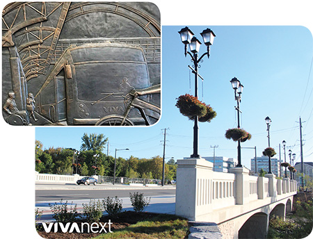
Who can remember? Not so long ago Highway 7 in Markham and Richmond Hill was a suburban highway: a few isolated developments, lots of parking lots and open fields, but no sidewalks, no plantings, no bike lanes–and certainly no dedicated rapid transit bus lanes. Just look at it now!

In only a few years from start to finish, construction begins and is completed on each of the rapidway projects. In the world of infrastructure renewal, vivaNext construction projects are known to be implemented very efficiently, and we’re doing everything we can to maintain that great reputation.

years of work are behind the design

What’s not so apparent to the public is the lengthy design process that happens long before construction starts. Design of the many engineering and architectural elements must take place stage by stage. Throughout, the designers need to balance staying true to the original vision with making it work in different conditions and geographical areas.

a variety of disciplines at work

VivaNext uses a multi-disciplined design team including: engineers who specialize in civil, traffic, structural, geotechnical, electrical and transit systems; architects; environmental consultants; landscape architects, security experts and more.

many stakeholders weigh in

At each stage, different options and features are reviewed, adjusted and improved with input from municipal staff, utility companies, local conservation authorities, property owners and others. Depending on the location of the project, specific design issues are addressed in conjunction with the owners of adjacent infrastructure including GO Transit, 407 ETR, CN, and the Ontario Ministry of Transportation.

the stages of each project

The process is not a fast one; the Environmental Assessment process, which established the conceptual design for vivaNext, was begun in 2002, and the whole process for any one segment from Preliminary Engineering to service start may take 6 or more years. Here’s an overview of the stages each of our projects go through, before shovels can hit the ground.

•    Environmental Assessment [EA]: The EA examines alternatives and identifies a preferred design. The vivaNext conceptual design shows the approach for individual segments like the number of rapidway and traffic lanes, boulevards and planting zones and the arrangement of stops and stations. The EA then identifies potential design impacts on the natural and built environment, traffic, noise, drainage, property, etc., and proposed strategies to avoid or mitigate and monitor them.

•    Preliminary Design: This stage takes design to approximately 30% completion and establishes the outlines of the project including its alignment and profile, what additional property is needed to build the project, development of major components like bridges or culverts for water crossings, entrances and intersections, utilities, and listing permits and approvals.

•    Detail Design: This stage fleshes out the preliminary design for all elements. For example, preliminary design may identify that a high retaining wall will be needed at a specific location; 60% design will show the kind of foundation needed and the wall’s general construction; 90% design will show the colour and design of the material to be used on the outside of the wall, and 100% will show all details and specifications required to construct the work.

•    Issued-for-Construction Drawings: These are the final design drawings to be used by the contractors, once all approvals are complete.

By the time vivaNext is complete, all our projects will share the original design vision, but their individual design will reflect local requirements and various conditions. Each segment is tailor-made to be functional, convenient and beautiful, with the primary goal of providing a rapid transit system for the future. Which is, and always has been, the ultimate vivaNext design objective.