Categories
Urban Planning

the roads ahead

the roads ahead

By now, our projects may be familiar to you if you’ve travelled through our rapidway construction areas, or seen the vision come to life on Highway 7 and Davis Drive. Curious about where the next projects will be? Well, future transit plans are always guided by many factors, including York Region’s priorities and the other changes happening in the GTA.

York Region’s overall priorities for roads, transit, cycling and walking are set out in the Transportation Master Plan [TMP]. From this, the region’s transit operations branch, YRT/Viva, creates annual Service Plans. Within the Service Plans, changes are proposed to routes where there appears to be demand, future development or transit connections. There are plans to complete the remaining rapidway segments along the existing Viva routes on Highway 7 and Yonge Street, and Viva routes will expand in the coming years along sections of Jane Street, Major Mackenzie Drive, and Leslie Street. Typically, new Viva routes begin with service at enhanced curbside stations. Then, once funding is in place, vivaNext takes Viva out of mixed traffic by building dedicated rapidway lanes, making it truly “rapid” transit.

As always, bringing subways to York Region is a top priority, including the Yonge Subway Extension and the Toronto-York Spadina Subway Extension [TYSSE]. The TYSSE will be generating excitement in the final year of construction as it makes history as the first TTC subway to cross regional boundaries. In the 2018 Service Plan there are changes being proposed as part of the Spadina Subway Transit Strategy [SSTS], helping Viva riders connect to the new subway.

So what can we expect to see on the roads ahead? We’re certain to see transformations – ones that connect transit and people – that we made together with you. And now, it’s back to building what’s next as spring construction is ramping up with better weather on the horizon.


Categories
Live-work-play Urban Planning

Seeing into the future with York Region’s Official Plan

futurebuilds

What’s the best way to see what the future will look like for York Region? A crystal ball? Cards? Tea-leaves?

In all seriousness, when it comes to reading the future for our community, I suggest you look at York Region’s Official Plan. This document, which is a critical planning tool, has a number of functions: it’s a public document used to describe and promote our vision for the future, but it is also a legal document used to support and defend key decisions related to public infrastructure, development and growth.

Based on a 25 year planning timeframe but updated every five years, York Region’s Official Plan sets out several key themes which will guide planning decisions, and will help make growth work for us.

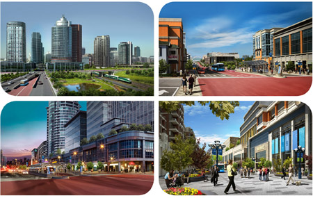
One of the main themes throughout the plan is the desire to concentrate growth and development in key areas through the region. This will be done through the further development of a series of centres and corridors, meaning new downtowns in Markham, Newmarket, Richmond Hill and Vaughan. The idea is that by building more intensively in these areas, there will be less pressure for growth in the existing communities.

These new multi-use centres will be connected by transportation “corridors” that will make it easier for people to get around the region. And obviously, the best way to travel will be on the vivaNext rapidways, which will run along the corridors and connect the centres.

As they develop, the centres will become focal points for exciting new destinations, offering more choices in entertainment, dining, shopping, and other kinds of attractions. They will also provide higher density housing in condominiums and apartments, for people who like the idea of living at the centre of the action. These new downtowns will be designed with people in mind: they will include attractive, public open spaces where people feel welcomed, and be designed in ways that encourage walking, cycling and transit use.

The Official Plan recognizes that while many people may like the idea of heading to one of the newly urbanized centres to dine out, to shop, or to go to work, they may also want to have a home in a quiet residential neighbourhood. So the Official Plan directs that those kinds of communities will be protected from the kind of intensification that will be used in the centres, so people can continue to enjoy the lifestyles they already have.

And because people in York Region value the greenspaces that make up such an important part of this area, a full 69% of the Region’s landmass will be protected as either Greenbelt or Oak Ridges Moraine.

The Official Plan goes into a lot of detail on these main themes, as well as a range of others, and is well worth reading to give you a sense of how your Region is going to manage growth into the future, and how it is going to evolve.

I like to think that with this well-thought-out plan, people in York Region will truly be able to have it all: our familiar communities will be protected, but we’ll get the benefits of city-building; and we’ll have a great rapid transit system to move us easily between all sorts of exciting new destinations. We’d love to hear your thoughts on this future vision, and what it will mean for you and your family!

Categories
Live-work-play Urban Planning

Shaping the vision for the future

official-plan_2010_06_071

When you think of York Region, what comes to mind for you? The comfortable, tree-lined family-friendly neighbourhoods of Aurora or Vaughan? Or maybe the increasingly urban appearance of Markham’s new development areas, with many large head offices employing thousands of professionals? Or maybe the quaint, walking-scale downtowns of Newmarket, Unionville or old Richmond Hill? Not to mention the lovely green countryside that wraps all around our towns, offering recreation, productive farmland, and rural lifestyles. Maybe you think of how some downtown sidewalk areas could be more inviting, how much longer it’s taking you to get to work these days, or how it’s hard to get from A to B in York Region if you don’t have a car.

It’s probably safe to say that everyone in York Region has a view of what their home community means to them, and what they’d like it to be in the future. If asked, most of us could list the things we love, and the things we’d love more of (or in the case of some things, like traffic gridlock, less of!)

So when it came time to update York Region’s Official Plan, residents were asked to describe their vision for the York Region of the future. The input for the Official Plan makes a great snapshot of what people want out of their home in York Region, and what matters to them, which include:

  • Let’s be green;
  • Let’s try to live and work in the same community;
  • Let’s make it more beautiful;
  • Let’s make it lively, with lots of interesting things to do;
  • Let’s live in neighbourhoods that are designed to let us get to know our neighbours;
  • Let’s have more choices in housing availability, to accommodate every member of our community – families, single people, young and old;
  • And to tie it all together – let’s make it easier to get around, with or without a car.

That’s what people said, and then planners had to figure out how to make that vision come to life, looking twenty and even thirty or more years into the future. That vision is captured in a hefty document that is York Region’s Official Plan.

So what’s all this got to do with vivaNext? I’m going to tell you more over the next couple of blog posts, but here’s a hint: one of the key things that’s going to help achieve that vision of a greener, livelier, more compact York Region, is a rapid transit network. More than just transit, the vivaNext plan will help to shape our community into the future, and help bring those things people want – more choice, more opportunity, more green, more fun– to life. So whether or not you take transit, having vivaNext is very good news, and will be great for our community.

Categories
Live-work-play Urban Planning

Sand castles and city building

sandcastles-and-city-buildng_2010_04_29lRemember when you were a kid in a sandbox, and you could have endless fun with sticks and pebbles, building imaginary cities and towns, with houses, stores, roads and schools. You would make sure your city had everything people would want (including great rapid transit to zip people from the drawbridge to the castle), everything would be perfectly organized, and nothing would be too far away.

Believe it or not, there’s a grown-up version of that same activity, with the not-so-catchy title of Land Use Planning. Although you may never have heard this term, land use planning affects every aspect of life in your community today, and how you will be living your life in the future. And one of the most direct ways land use planning affects you, is through your municipality’s official plan.

Every municipality in Ontario must – by law – have an official plan, which has to correspond to plans already established by more senior levels of government. For example, York Region’s Official Plan has to fit within the overall Growth Plan for the Greater Golden Horseshoe, and York Region’s municipalities’ plans need to fit within the overall Regional plan.

Official plans are updated every few years, based on much discussion and public consultation. Just like the sand-box version, official plans identify which parts of town will be where people will work, which ones will be for housing, and which might accommodate both. Working with provincial rules, such as those set out in the Greenbelt Act and Places to Grow, official plans identify which parts of town will grow and which ones will be protected from growth. They identify the main roads, how much traffic those roads can carry before gridlock brings them to a stop, and where transit services will be needed to move people around.

(Hint – York Region’s current Official Plan, which I want to talk about more in my next blog, calls for a heavy expansion of rapid transit across the Region to help us cope with growth – which is why implementing our vivaNext plan is such a high priority for York Region).

Official plans also reflect the values and priorities shared by the community, such as a concern for the environment, or the need for a range of housing choices. An official plan reflects and shapes its community, and provides a road-map for how the community is going to grow – and respond to growth – into the future.

Of course, planning a real-life community is a huge responsibility that can affect the day-to-day lives of thousands or even millions of people. So getting it right is important, and takes a long time and a great deal of care; after all, unlike the sand version, redoing an official plan takes more than a sweep of a shovel. Hearing from the public is a critical part of developing an official plan – York Region’s current plan has a whopping 1,500 page appendix of submissions from the public!

So next time, let’s look at York Region’s December 2009 Official Plan, which highlights the importance of increased rapid transit for the York Region of the future. In the meantime, I’d love to hear from you: if you could go back to the sandbox, what would be in your perfect sand-city?

Links –
Ontario Ministry of Municipal Affairs and Housing Citizens’ Guides to Land-use Planning

Ontario Professional Planners Institute