Categories
General LRT Rapidways

choosing the right form of transit

In September the Province set up an expert panel to look at how Metrolinx should be expanding transit in the GTHA, and to propose realistic options to pay for it.  The panel has just released their second discussion paper, and it’s well worth a read for anyone interested in getting beyond the rhetoric and really understanding the facts and issues.

Certainly the issue of what transit technology should be funded, and where it should run, is a subject that’s dominated the headlines for months and is of interest to everyone.  It’s understandable that so many have views on this subject, and it’s also reasonable to expect that the people doing the planning should listen to those views.

But in the final analysis, choosing a mode of transit – the main rapid transit options are subway, LRT, BRT and commuter train – shouldn’t be treated like a popularity contest. There’s just too much money involved.  Each mode of transit has its uses, benefits and drawbacks.  Those qualities are well known to transit planners, and need to be thoroughly and objectively analyzed in the context of local circumstances including passenger volumes, current and anticipated densities, employment projections, and present and future land use patterns.

Planners ideally will look at a range of transit modes to meet the needs of users across a region or area, with the primary consideration being a seamless system that enables passengers to make easy, fast connections.  That doesn’t necessarily mean the trip will be non-stop, or use the same technology the entire way.

This is a concept we all already live with, so we shouldn’t expect transit to be any different. Pretend you are taking a trip to a small island in the Caribbean.  You’d probably drive to the airport, then you’d get on a big jet, then most likely transfer to a smaller plane for the last leg, or maybe even a boat if you were going somewhere out of the way. You’d never expect the big jet to swing by your house to pick you up at your door, then whisk you non-stop to the tiny island.  Getting around the GTHA, depending on where you’re travelling from and to, follows the same logic.  Some riders may need to take surface transit, then transfer to one form of rapid transit – and then possibly to another mode to complete their trip.  The key point is to create a system that gets you there as fast as possible.

In a world where there’s only so much new money available for transit, careful decisions are needed to ensure final choices get the greatest number of people into transit, reducing gridlock on the road system.  The most costly option – subways – should be reserved for where it will do the most good, i.e. get the greatest number of cars off the roads.  Given that the need for new transit massively outstrips the money available, every single transit dollar needs to be spent wisely.

Professional analysis of facts has always been the basis for our vivaNext decisions. That’s why we’re installing BRT – the lowest cost form of rapid transit – along Highway 7, with the option to change to LRT when future volumes justify it.  On the other hand, the ridership and future employment projections do justify the cost of extending the subways north to the VMC, and along Yonge Street from Finch to Highway 7, so our plan includes subways too.

We’re proud of the system we’ve planned and are building for York Region, and are looking forward to the day when it will be connected to a system that covers the entire GTHA.  Now that’s something we think everyone will support.

Categories
General Going Green LRT Rapidways Subways Urban Planning

Key international publication identifies GTA’s transportation challenges

The Organisation for Economic Co-operation and Development (OECD) is one of the world’s largest and most reliable sources of comparable statistical, economic and social data. In a publication launched in November 2009 entitled “OECD Territorial Reviews: Toronto, Canada”, several of the GTA’s transportation challenges are collectively identified as a key policy issue. They include traffic congestion problems (70% of commuters use cars), poorly integrated regional transit services, and relatively underdeveloped public transport infrastructure.

To address this key policy issue, one of the publication’s key recommendations is to “tackle transportation challenges by creating incentives for reducing car use, access to additional revenue sources, [and] longer term funding commitments by federal government for investment”.

Here in York Region, we are doing our part to tackle these transportation challenges with such vivaNext initiatives as the rapidways, subways and proposed LRTs. In addition to making it faster and easier to get in and out of the GTA, they will make it up to 40% faster to travel along our Region’s busiest corridors. We believe that such incentives will significantly reduce car use, lead to economic revitalization, help the environment, and maintain the quality of life our residents have come to enjoy.

Categories
Live-work-play LRT Urban Planning

Successes in Portland with the “Total transit system”

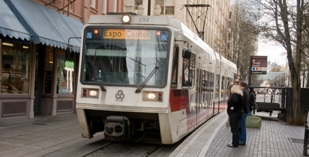
Part of the total transit system in Portland, Ore.

While we enjoy talking about our projects, it’s also important to highlight some of the other positive transit initiatives that are going on around the world. Before we first launched Viva, we looked to other cities to see what lessons we could learn. One city that provided inspiration was Portland, Oregon.

Fred Hansen, Portland transportation manager, was recently featured on The Agenda with Steve Paikin talking about the “total transit system”. He said it’s not only about reducing travel time, but it’s about being able to properly plan your trip by knowing exactly when a transit vehicle will arrive. Portland uses light rail, commuter trains, streetcars and buses to move people.

They also have something called “frequent service”, meaning no matter what day or time, a vehicle will be there within 15 minutes on a frequent service route. Hansen said that when people can count on a vehicle arriving, they have seen triple-digit increases in ridership. Portland uses GPS so riders can go online or call to find out exactly what time a vehicle will arrive.

But Hansen said what they really want to do is create neighbourhoods – that it’s all about livability. A residential community is not just a place where people sleep or have a meal, but it should also be a place where people can get a glass of wine or a cup of coffee. The downtown core shouldn’t just be a place where people work. It should also have services and places for people to live. Transit has to reflect the community and be a part of the streetscape.

While the program focused on how Toronto can learn lessons from Portland, I would like to highlight the initiative of Portland and say that we hope to bring all these ideas to York Region and more. In fact, many of the ideas were initiated with phase one of Viva including using GPS so riders can know the exact arrival time. VivaNext will continue to build on leading industry standards that ultimately improves quality of life.

The ideas Hansen talks about are the same ideas we talk about around the office every day. We are using transit to lay the ground work for communities where people don’t just live, but also work and play. That is the end goal, transit is the medium.

What do you think of what Portland is doing? What other good ideas do you think we can copy from other places in the world?

I encourage you to watch the full conversation between Fred and Steve. It is followed by a panel discussion about how to share the road.

Watch the show

Categories
Announcements Community Events LRT

Light rail transit coming soon to York Region

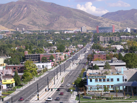
An aerial view of an LRT line in Salt Lake City, Utah showing the transit-only centre lane tracks on which vehicles travel.
An aerial view of a TRAX LRT line in Salt Lake City, Utah with dedicated, transit-only lanes. This is similar to how the Leslie/Don Mills corridor line will be designed.

Imagine a light rail line that could take you from Danforth all the way up the Don Mills/Leslie corridor into Richmond Hill. That was one of the transit projects identified by Metrolinx near the end of last year as part of the master plan for transportation in the Greater Toronto and Hamilton Area.

The light rail line study is now underway and we want your input. We are having a public meeting on Wednesday, June 10, where we will present our plan for the York Region portion of the line that will run on Leslie from Steeles to Highway 7.

The City of Toronto and the Toronto Transit Commission (TTC) are currently undertaking a preliminary planning study to identify an LRT route in this corridor from Danforth to Steeles. Although we are conducting different studies, we are working with staff at the City of Toronto and TTC on the light rail line.

Similar to our vivaNext rapidways, the LRT vehicles will operate in their own right-of-ways – enabling them to safely speed past congested traffic, no matter what time of day.

Like all of our projects, we want to ensure that anyone with an interest in the study has the opportunity to get involved and have their voice heard.

What do you think of a light rail line through this corridor? Join us in person for the meeting or, if you can’t make it, let us know your thoughts by commenting on our blog.

For more information on light rail transit or the current studies please see our website

The meeting will be held:
Wednesday, June 10, 2009
6:30 to 9:00 pm

Hilton Garden Inn
300 Commerce Valley Drive East,
Thornhill, ON

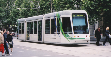
An LRT vehicle traveling throught the streets of Melbourne, Australia.
An LRT vehicle traveling through the streets of Melbourne, Australia.